Difficulty 2 out of 5
Distance 6.52 km
Elevation difference 434 m
Duration 2 h 30 min
Maximum altitude 714 m
Circular route
PalmA well-known beer brand focuses its summer campaign around the slogan 'The same old thing'. But the same old thing is never the same... why does one have six letters and the other only five? No, because many factors come together in an experience and determine it: people, light, atmosphere, weather, color, etc. Many hikers (myself included) often find that no matter how many times they do the same route, it's not always the same, it's not always the same; the difference? Nuances; because they will never hear it (we will never hear it) the same way they always do it. We will do the same thing, but it will never be the same.
On this route, we visit an environment that is surely deeply familiar to us. The commune of Valldemossa is documented under the name Puig Comú in the Capbreu from 1517. Communal lands constituted an essential source of natural resources for peasant economies, providing firewood, timber, pasture, hunting, and, in some specific cases, even fishing. "We must understand the establishment of communal spaces as a common practice within the logic of the expansion of the feudal system, and in Mallorca within the context of the island's forestation, as a concession made to the inhabitants who participated in this process after the Catalan feudal conquest. Therefore, the lords would favor the transfer of spaces for exploitation." (Guillem Barceló y Ramis, Communal property and anti-manorial conflicts: The communes of Muro and Santa Margalida (16th-18th centuries)The commune of Valldemossa was sold, like many others in Mallorca, to private individuals a few years before 1880, as is evident from the Archduke when he comments in the The Balearic Islands that the common was "a formerly public forest that has recently been sold."
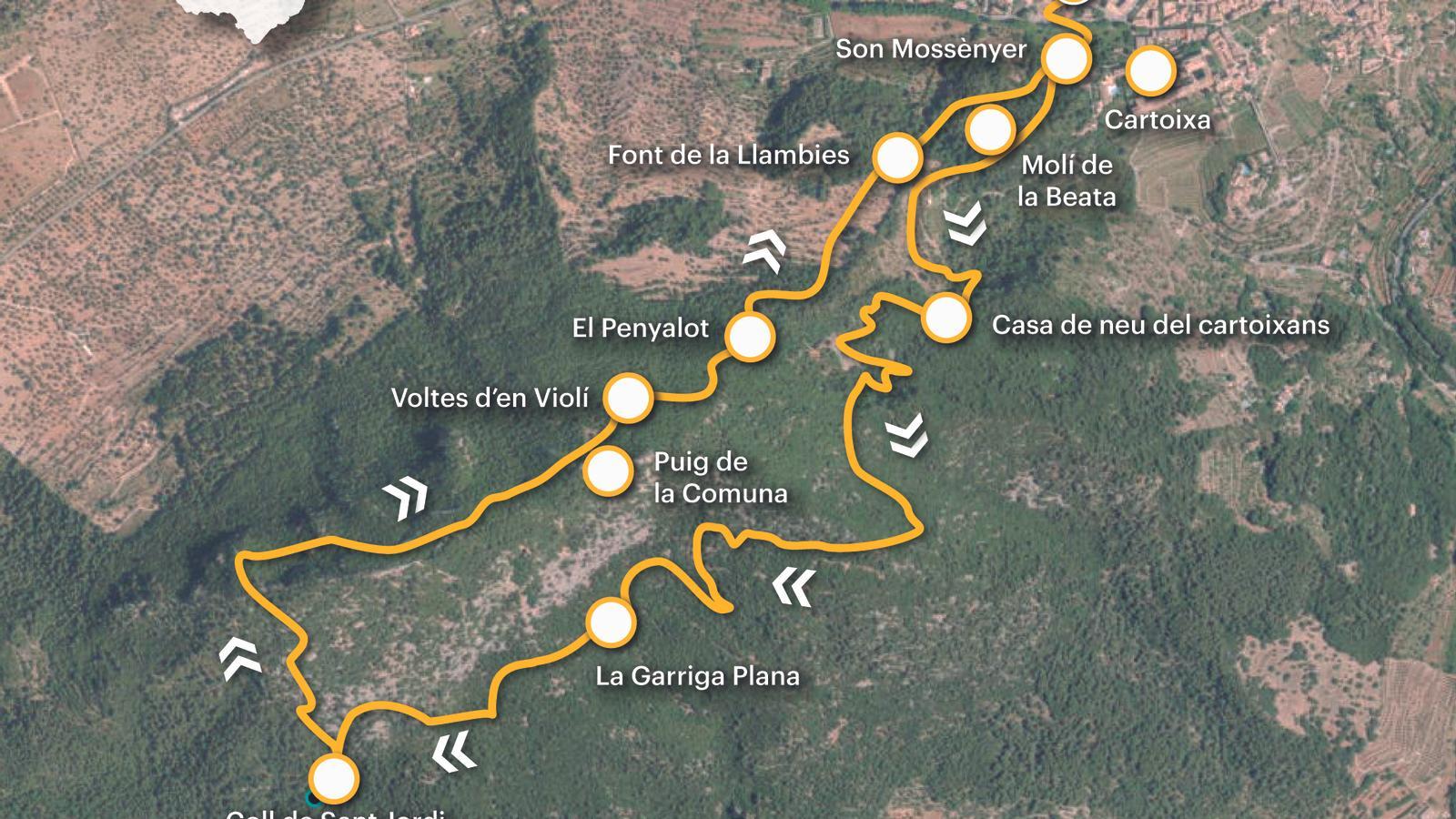
[00 min] We start the walk from the same bus stop (L-213/check availability and schedules on the website) tib.org), in Campdevànol square. From there we head into the town. As soon as we enter, in the square dedicated to the musician Bartomeu Estaràs i Lladó, in Tomeu Reüll, we turn right onto Uruguay Street and then right again onto the Son Mossènyer path. [05 min] We soon come to signs for the GR-221 (Stage 4: Esporles - Deià), which we will return along. We now follow the path, a concrete track, that curves to the left around the hill of Molí de la Beata. After passing under the aqueduct that supplied the Charterhouse with water from the na Llambies spring and skirting the former Carthusian olive oil mill, the path climbs up the coast towards the Teulera house.
At the last bend before the aforementioned house, we find on the left the path that will lead us to the Carthusian snow house through the so-called Bosc dels Frares, a leafy holm oak grove that adorns the slopes of Mount Comuna. [15 min] Located on the old Guix road, work on this snow house was completed on July 25, 1697. Its two most notable features are its oval floor plan and its elevation, below 500 meters. The continuation of the path is to the left of the snow house, which now takes us to the Cartoixa lime kiln, one of the largest in the Serra. It is just a few meters from the main path, on a branch that descends a few meters towards Teulera.
The path, now a cart path, climbs via a drag that we eventually leave on the right. The last curves are a bit rough and we end up at an old gate without a barrier [30 min]. We begin a flat stretch that, to our right, offers a beautiful panoramic view of Valldemossa and the surrounding mountains among the holm oaks: the Atalaya Vella, Mount Caragolí, the Teix, and the Pastoritx peak. At the height of a large fallen holm oak, just as the path takes flight again in the direction of Penyalot, we should see on the left the start of a flat path towards Llebeig. After a very gentle climb, we reach a fork; we continue left to end up on a natural viewing platform [40 min], where the path seems to have no continuity. To the right of the esplanade, a margin with some stakes embedded between the stones. At the foot of the wall, we find the continuation of the route to the west. The path soon opens onto a wide, clear cart track.
Upon reaching the place known as Garriga Plana [1 h 00 min], we come across a hut and a lime kiln. The wide path continues toward the houses of Sa Baduia. We turn right, toward Llebeig, following milestones. We knock down a wall through an open passage and shortly after, we come across another lime kiln. Here, we turn right again, following a path that will soon take us to the Sant Jordi pass (1 hour 10 minutes), where we join the GR-221. The wooden stakes appear above the pass itself, where we turn right toward Valldemossa along the Monte de la Comuna path. Despite the time that has passed since the disappearance of the traditional trades of the Serra (charcoal burner, calciner, and ice-maker, among others), the entire environment maintains the imprint of the past on the land.
The climb isn't long, but it is somewhat arduous due to the steep slope. However, the beautiful landscape and the views more than make up for it. If we follow the signs for the Dry Stone Route, we won't get lost. After crossing a landing with two small huts and the remains of a charcoal burner's ranch, [1 hour 50 minutes] we reach a hill, to the right of which we have Mount Comuna. However, to the left, there is a much more accessible lookout point with a very good view. We continue our itinerary, now clearly descending towards Valldemossa. First along the short and beautiful section known as the Voltes d'en Violí. Then, the path turns right and leads us to the Penyalot plateau [2 hours 00 minutes], an esplanade where we find a pond, covered with a stone vault, and a hut attached to the rock that gives the area its name.
At this point, to our left, begins the Callejón de la Comuna, an old bridleway where we find two points of special interest. The first is a large rock marked with a cross [2 h 10 min]. It marks the spot where, during the plague of 1652, a lazaretto was established to isolate the sick from the rest of the Valldemossa population. The second point is the Fuente de na Llambies [2 h 20 min], one of the sources that supplied water to the Cartuja monastery. The last stretch of the path borders the Molino de la Beata, closed to the public due to its dilapidated state, until it comes out again onto the Son Mossènyer road. From here we are just a few minutes from the town [2 h 30 min].
Difficulty 2 out of 5
Distance 6.52 km
Elevation difference 434 m
Duration 2 h 30 min
Maximum altitude 714 m
Circular route
@Fita_a_Fita
