Difficulty 2 out of 5
Distance 11.7 km
Elevation difference 167 m
Duration 3 h 05 min
Maximum altitude 285 m
Circular route
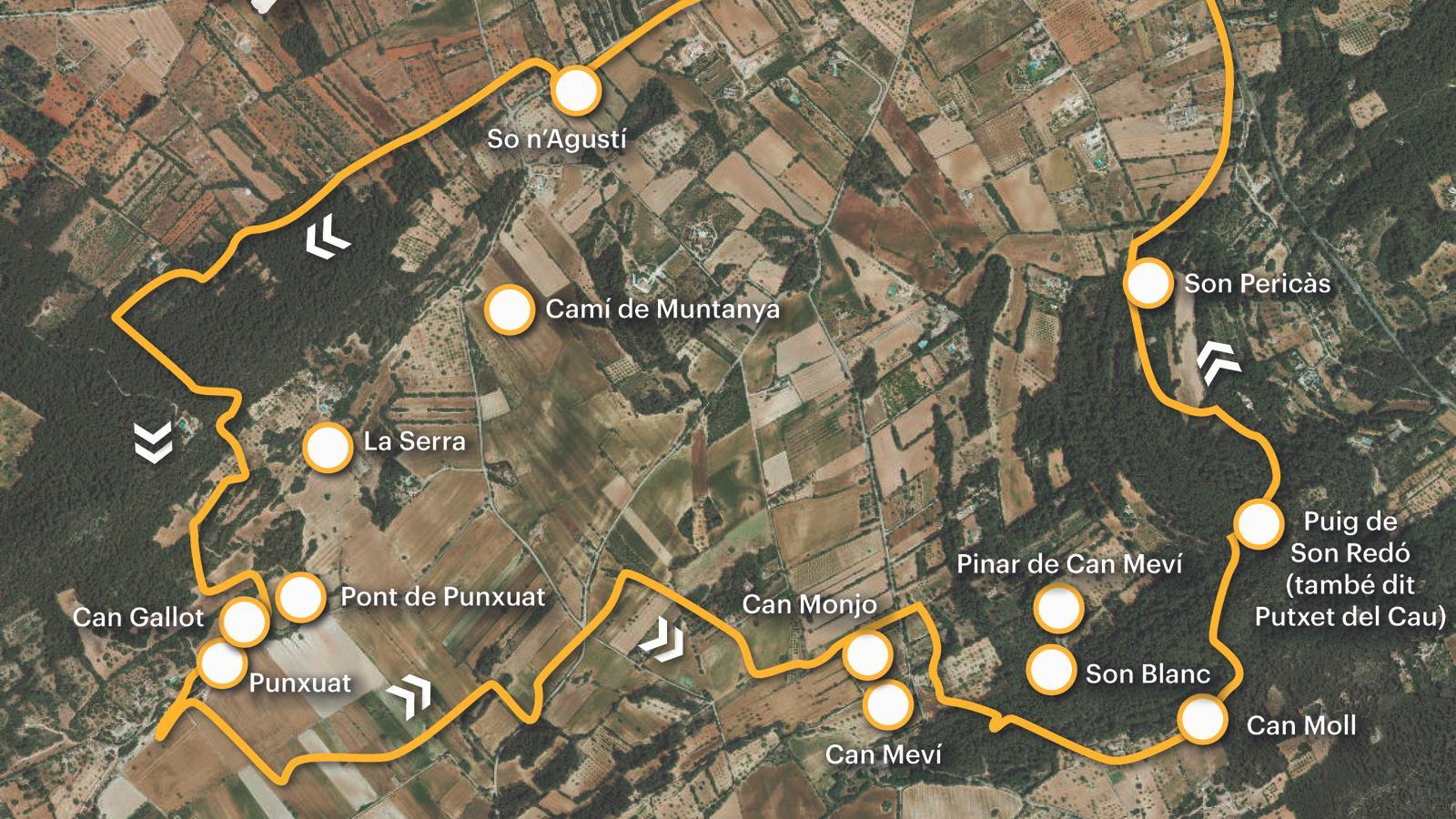
PalmIn the following itinerary, we suggest a gentle and pleasant trek to the caudí. Paths and landscapes steeped in character and unique beauty, with a wealth of tradition and feeling, will take us on a tour of the lands of Punxuat, a place steeped in thousands of years of history. For those who use public transport regularly, you should know that the following lines are available to reach Algaida: 401, 403, 431d, and 432; the first two connect with Palma (for more information on schedules and availability, see the website). tib.org). The starting and ending point of the walk is the Farinera parking lot, near the Porrassar sports center, behind the Casal Pere Capellà.
[00 min] From the Plaza de la Farinera, around midday, we head towards Colomer Street, through Jaume I Street, between three flour mills: the Boi Mill, on the right, and the Nou and Nofre Mills, on the left. We continue along Sol Street, towards Llebeig, towards the Foravila (Algaidí) area. Before that, [10 min], we will come across two more mills, Roig and Bossa, on the left and right of the street, just above the fork between Son Miquel Joan, on the left, and So n'Agustí, on the right. Further to the right, Cabrit and Bassa Streets.

We continue along the So n'Agustí path, with the Serra hill in front of us. We come face to face with the manor houses as we come out onto the Montaña path [25 min]. We turn right and just a few meters later we turn left, continuing our walk along the Camp Gran path, amidst carob groves, extensive crops, and stretches of scrubland, with the occasional chalet. [35 min] The dirt path turns sharply to the right, and immediately afterward we reach a path on the left, where our route now continues. We pass a dividing wall and the path turns gently to the right until it comes across a wire fence. We continue on foot and come out onto a dirt track.
[45 min] We advance a few meters and watch for the start of a new path on the left, oriented towards chaloc, which gently climbs along the coast of the Sierra, an elongated hill that extends between Son Agustín and the Commune. The path first turns to the right over the hill, crosses a wall and opens onto a new path, a continuation of the Purgatory path, which we take to the left. We go around some crops. [1 h 05 min] Finally, we come out onto the Punxuat path, which we join on the right to head towards this historic estate. However, we first pay a visit to the Punxuat fountain, along the first path we find on the left [1 h 15 min].
"Very close to the houses, at the bottom of the slope that closes the Punxuat hillock, is the fountain, which is nothing more than a covered drinking trough, fed by a drip. In the past, when Can Gallot did not have a cistern, they used this fountain for after the fountain and for all their needs. About three or four years ago, but now it flows again and spills over the surface all winter long. (The possessions of Algaida. Miquel Sastre Pujol 'Fiolet'. Algaida Town Hall, 2000). We learn more through speleologist José A. Encinas, who explored the interior of the fountain. He entered this Muslim-era hydraulic system through the eight-meter-deep mother shaft and retraced its practicable sections, a total of sixty-five meters. The house or chapel where the fountain is located dates from the 19th century and has been recently restored.
We go out again to the Punxuat road and approach the houses [1 h 20 min]. The place has a few thousand years of history. Just behind the houses is a prehistoric cave and next to those of Can Gallot, neighboring Punxuat, there are several tombs excavated within the rock, probably dating from the Neolithic period (1,500 to 1,200 BC). The houses and lands of Punxuat, a toponym of unknown origin, already appear in the Cast Book This building was used as a winery until the outbreak of phylloxera in 1891, which destroyed nine plots of vineyard. It was later used as a barn. There is also a defensive tower dating back to the 13th or 14th century. The chapel, crowned by a small, rustic bell tower, is shaped like the old repopulation churches of the 13th and 14th centuries. In the 16th and 17th centuries, Punxuat was owned by the noble Santacilia family until they sold it to the Algaida Town Council in 1668. It then became communal property, which was subsequently subdivided into several subdivisions until the 19th century. The houses then passed through various owners.
We follow the Punxuat path around midday. Soon we find a dirt track on the left that descends into the valley [1 h 25 min]. Shortly after, we must turn 180 degrees to the left, to reach the center of the comma, below the slope, and finally, to the right, cross the comfrey and join the Clot de Punxuat path [1 h 35 min], which we follow to the left. After a short and scenic route, we come out onto the paved Son Miquel Joan path, which we join on the left, heading towards Algaida. When we reach the junction with the Montaña path, we turn right onto the So n'Horrac dirt track [1 h 50 min]. We soon see the houses of Can Monjo and Can Meví. When we come across a pine forest, perpendicular to our path, we turn left onto a path that we will use as a shortcut to reach the Son Roig path. Beforehand, some barriers force us to cross a pygmy dam and brush past a seedbed. The path leads us parallel to a dry wall, which we can soon cross and continue along the right path to the access road to the Son Roig vineyards [2 h 05 min].
A few meters before reaching the vineyards, we turn left onto the Camino de la Coma, which passes between Son Blanc and the pine forest of Can Meví, on the left, and Can Gustinet and Son Bandoler, on the right. At the first fork, we turn left. [2 h 20 min] We reach a village-like group of houses called Can Moll. The path continues on the left, behind the houses. We soon leave it, because we mark out a path on the left, closed with a chain, which crosses a comma and climbs steeply over Mount Son Redó, also called Putxet del Cau [2 h 35 min]. The summit is a rocky outcrop marked with a small cairn. We follow the path which, upon reaching a dry wall, turns left and descends towards Son Pericàs, passing the houses on the right. At the end, we come out onto a new path that we take to the right, which should take us along the Old Road from Algaida to Llucmajor, near the Diguessó coast [2 hours 55 minutes]. From there, to the left, we are next to the village of Algaida, where we conclude the route [3 hours 05 minutes].
Difficulty 2 out of 5
Distance 11.7 km
Elevation difference 167 m
Duration 3 h 05 min
Maximum altitude 285 m
Circular route
@Fita_a_Fita
