If you're interested in participating in this guided tour led by Joan Carles Palos, please visit the following link . Additionally, if you're from Mallorca and interested in attending, the ARA Baleares is organizing a trip to Ibiza , which includes this tour, the Botafoc tour, and a tour of the port of La Savina in Formentera, on the 7th, 8th, and 8th.
Milestone by milestone
La Savina, a busy gateway to Formentera
A route through the port's historical and natural heritage, from Peix Lake to Llamadores Beach along the Old Guide Trail.
14/07/2025
4 min
Palm"It has a somewhat colonial air, as corresponds to the latitude of its location, 38º44'N. It belongs mainly to the Portossaler inn. It is a port open to the east, but most of the year it is as placid as a sunset. It has a dock with rather low, cuboid, charred buildings, and leisure. It has a row of palm trees that separate these spaces from the fishermen where they stow nets and all kinds of seafaring utensils. This is how the Catalan writer, doctor and politician Joan Colomines i Puig (Barcelona, 1922-2011) describes the port of La Savina in his book Formentera, Published by the Balearic Government in 1992. A frequent visitor to the island, he was a keen observer and, at times, also a protagonist of the social and cultural changes that took place on the island.

Colomines welcomed us at the entrance to the port of La Savina. We may notice substantial changes between the described past and the lived present. Not surprisingly, more than thirty years have passed. However, the port of Formentera, like the rest of the island, still retains the essence of an island that struggles against the external elements of modernity to preserve its vibrant and active cultural and linguistic landscape. The following route is an initiative of the newspaper ARA Baleares and the Port Authority of the Balearic Islands to convey and publicize the secret heritage of our ports. We do not detail schedules, only the length of the route, the gradient, and the maximum height. Ultimately, it is a walk—which we can take alone or with others—through streets and squares full of stories, legends, and an immense architectural and cultural heritage that requires time and calm to explore unhurriedly and with all five senses.
The route
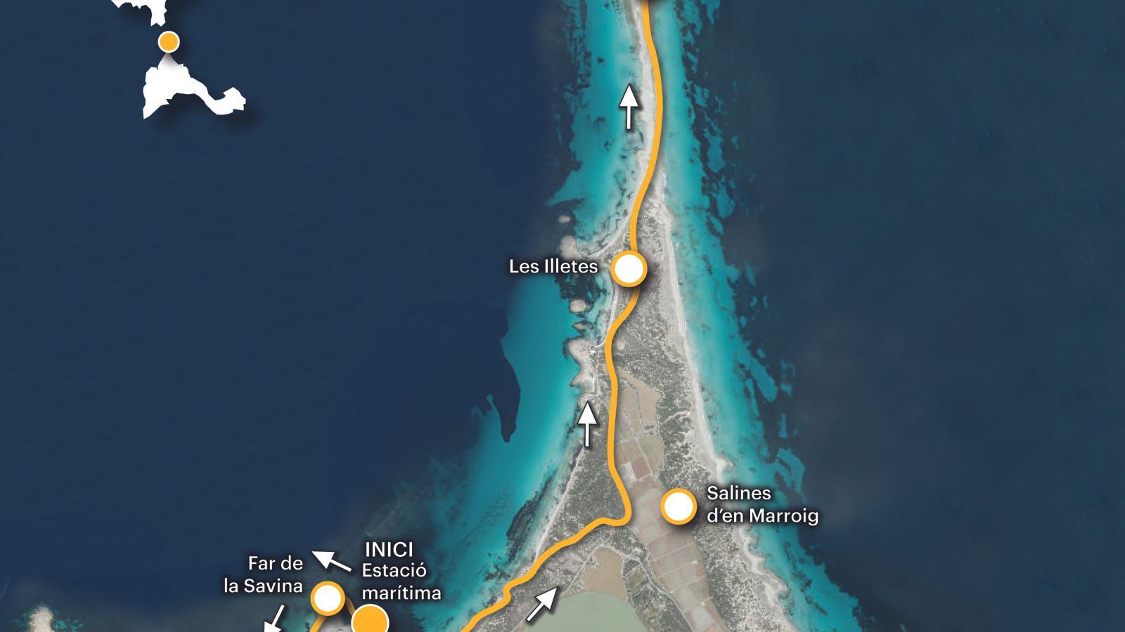
We start walking from the ferry station towards the La Savina lighthouse, on our right. We follow the promenade, which, along the seafront, will lead us to the Veleta, at the beginning of the Paseo de la Marina, on our left. We will then scan this curious octagonal structure with our eyes. Opposite this space is the Pez pond. We approach by following a dirt path that passes in front of some houses and crosses a public parking lot. We reach the Boca, the point where the pond connects with the sea.
Do you want to sign up?
Until the end of the 19th century, this lagoon was where most boats anchored, mainly fishing vessels, which, due to its shallow draft, were the only ones able to access it. The larger ships, responsible for transporting people, goods, and salt, had to anchor near the old islet of La Savina before the construction of the new port in 1901. From this point, La Boca, looking towards Chaleco, we can see the old colony facilities. Just 800 meters from the port and accessible from the road to the La Mola lighthouse, this is a concentration camp that operated between 1939 and 1942. At one time, it housed more than 1,400 prisoners of Franco's persecution in inhumane conditions. Joan Colimes dedicated a poem to him, from which we reproduce the first lines: "Cemetery of the living, now all rubble/dumped into the pond, with the joy of fish/still everything is hunger, one can still feel/the howl of the dying and the weight of the sun."
Let's go back to the Veleta. Designed by Rafel Soler in 1988, it consists of a set of eight sundials, each oriented toward one of the eight winds—tramontana, gregal, levante, chaloc, mediodía, lebeo, poniente, and mistral—of the world, crowned by a panel. The entire work is a replica. roughly speaking from the Tower of the Winds of Athens. Its position coincides with the connection point between the oldest part of the port, the La Savina breakwater, dating from 1901, and the new port facilities developed between the 1960s and 1980s. Each year, more than two million passengers pass through these spaces. We continue our walk along the Paseo de la Marina. Soon, we spot an old, dilapidated building on the right, the Guafe. Salt production was once the main industry on Formentera; an impoverished, sometimes uninhabited island dedicated to agriculture and fishing. The salt was transported in wagons to the dock, known as 'El Guafe' (from the English word for 'Guafé'). wharf, that is, dock), where the salt was loaded onto the barges that transported it to the cargo ships anchored next to the islet of La Savina. A walk towards the Isletas and Los Llamadores beach. This is the Camino de la Guía (Guide Path), so named because it was where the very narrow-gauge railway line ran for transporting salt from the Marroig salt lakes to the loaders ('Guafe') at the port of La Savina. It allows us a comfortable and flat approach on foot to this idyllic corner of the island. We can easily estimate the walk to the end of the route in between three-quarters of an hour and an hour.
Aside from the ethnological richness of the surroundings, a rich cultural landscape, we find the heritage value of a natural environment that has formed the Ibiza and Formentera Salt Flats Natural Park since 2001. The Marès well, Lake Pudent, the Marroig Salt Flats, the Illetes, and the Llamadores are some of the points of interest along the route. But the Guide's path offers, above all, a charming view of Puerto de la Sabina, which we can enjoy both on the way there and on the way back. We conclude this walk with the verses that close the poem. Formentera (1958), by the Ibizan Marià Villangómez: "Formentera: sea and sky/around a heart of greed./Beauty is stripped bare/to join with dry roots."
The data
Difficulty 2 out of 5
Distance 10.13 km
Slope 1 m
Duration ---
Maximum altitude 5 m
Non-circular route
@Fita_a_Fita
