Difficulty 2 out of 5
Distance 11 km
Elevation difference 415 m
Duration 3 h 00 min
Maximum altitude 258 m
Non-circular route
PalmMount Nunó is a mountainous elevation located on the west coast of Ibiza, in the municipality of Sant Antoni de Portmany. It measures 258 meters in height and marks the beginning, on the western coast, of the northern mountain range known as Els Amunts. It forms high cliffs overlooking the sea that are an emblematic point on the coast, as they are visible from anywhere around the Bay of Portmany. At its summit is a geodesic vertex. The name derives from one of the Catalan lords who arrived in Ibiza in 1235, Nunó Sanç, who was awarded the quarter of Portmany; in fact, this mount served as a demarcation between this quarter and that of Balansat (Guillem de Montgrí). At the top of the mount, you can find remains of stones that bear signs of having served as milestones in different eras.
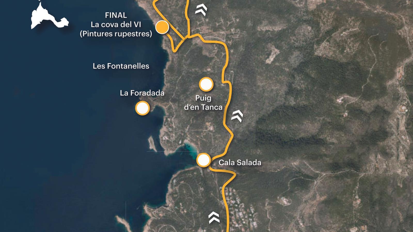
Cala Salada, the start of our route, is located north of Sant Antoni de Portmany. To get there, follow the Corona road (EI-651). After about 2.5 km, you will see signs on the left for the turnoff to the cove, one of the most visited in Ibiza during the summer. Public transport is available on lines 30, which connects Sant Antoni, Santa Agnès, and Ibiza, and 34, which runs from Sant Antoni to Cala Salada via Can Coix, and is only available during the summer months. We suggest starting the walk from the same road. Finally, all historical, geographical, and toponymic information is taken from various articles published in the Encyclopedia of Ibiza and Formentera (www.eeif.es).

[00 min] We set off from the Corona road, following the signs for Cala Salada and the archaeological site of the Cueva del Vino, also known as Les Fontanelles. The paved road winds its way between fields on the left and the Can Germà residential area on the right. Little by little, we descend towards the sea. After passing through a sort of monumental gate, used as an access control in the summer months, [15 min] we exit the Cala Salada road to the left and then turn right. Calle del Xaloc leads to a pedestrian path that we continue on until we reach the cove's public parking lot [20 min].
We return to the paved road towards the sea. Right at the first bend, on the right, we find the track that we must follow from now on. [25 min] The path leads us through a narrow, deep gorge where the Besora stream, also called the Perdiu stream, flows. This stream is a subsidiary of the Cala Salada stream. It rises in the Hereva fences on the inner slopes of Mount Nunó and joins the main stream next to the cove where it flows into the sea. The pines rise lushly towards the sky, waiting to satisfy their thirst for sun. The track climbs up the slopes of Mount d'en Tanca, to the left of the gorge. [45 min] We reach a west-facing hill with Mount Nunó in our sights. We leave a group of chalets (Can Vicent dels Concons and Can Marianet) on the right and continue for a short stretch along the dead-end track that circles the mountain to the Punta de la Pedrera, above Cala Salada. [50 min] We turn right onto a dirt road that will take us to the next major fork, above the Les Fontanelles cliff [1 h 05 min]. Before that, we'll pass two paths on the right. The third will take us to the cave.
The path to the Vino cave is very eroded by the action of the water and as we approach our objective it becomes more roasted and stony. [1 h 10 min] Located between La Foradada and Cape Nunó, 50 meters above sea level, this shelter, more than a cave, used in the past as a winery, contained some cave paintings – invisible today due to their lamentable state of conservation – initially dating back to the Bronze Age; although subsequent research has raised the possibility that they are Punic (4th-6th BC). These cave paintings were discovered and studied by the French prehistorian Henri Breuil l'Abbot Breuil on a trip he made to Ibiza in the spring of 1917.
We go back to the last fork [1 h 15 min] and turn left onto a dead-end track that points directly towards Mount Nunó. First, we pass a chalet on the left, built on the cliffs overlooking the cave we just visited. At the end of the trail, we come across the entrance to two more chalets [1 h 20 min], to the right of which lies the path that climbs to the top of the peak. At first, it looks like a cart track, but soon becomes a rough and stony mountain path. And so it goes until the end, at the foot of the geodetic vertex that indicates the highest point, the 257-meter altitude of Mount Nunó [1 h 35 min]. This peak, also known as Hereva Hill, is located at the southern end of the Amunt mountain range, which runs along the western and northern coast of Ibiza, between the municipalities of San Antonio de Portmany and San Juan de Labritja, from Cape Nunó to Punta Grossa. It's an ideal geographical area for hiking.
We begin the descent following a path that heads from the summit toward the gravel. This descent seems more comfortable and peaceful, without any trace of the gentle slopes we climbed. [1 h 55 min] The path leads to a cart track that we take to the right, near some half-collapsed houses known as the Hereva kitchens. We have already mentioned that Mount Nunó is known in Santa Agnès de Corona by this same name (Puig de la Hereva), due to the name of the family that owns it. The Hereva fences are also related to this place name. On the way down, we come to another fork [2 h 05 min], where we take the path to the right to exit onto the dirt track where we began the ascent to the mountain [2 h 10 min].
Without any major difficulties or surprises, we finished the walk along the Cala Salada road, between the public parking lot and the beach [2 h 35 min]. We can spend some time leisurely visiting the cove and even take a tour if we wish. Cala Salada is an inlet on the western coast of Ibiza, located between the inns of Les Rotes and Cas Ramons, belonging, respectively, to the villages of Santa Agnès de Corona and San Antonio de Portmany, in the municipality of the same name. Precisely the fact that Cala Salada has good shelter, with a large number of boatyards, could be the basis for the origin of the place name. Everything points to the name coming from Latin. celatus, meaning 'hidden' or 'concealed', which would have evolved into the later 'salada'. Once the visit is over, we head up the Conora road, where we end the route [3 h 00 min].
Difficulty 2 out of 5
Distance 11 km
Elevation difference 415 m
Duration 3 h 00 min
Maximum altitude 258 m
Non-circular route
@Fita_a_Fita
