Difficulty 3 out of 5
Distance 10.95 km
Elevation difference 413 m
Duration 3 h 30 min
Maximum altitude 305 m
Circular route
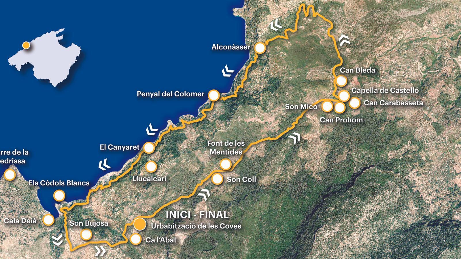
PalmOn this circular route, we connect two very important routes in the context of the communications network of the Tramuntana Mountains: the Castelló and Baix routes. The former was the main route connecting Deià and Sóller, that is, the Royal Road, along which the entire life of that region was aligned. It is not in vain that we find some of the most important and long-established estates in the mountain range, such as Son Coll, Son Mono, Can Prohom, and Bienes de Avall, among others. The Baix route—as opposed to the Amunt or Grao route, also called the Son Coll or Castellón route—is a very old route that ran along the same maritime slope of the Tramuntana Mountains as the former, although much closer to the sea.
Of the entire route, we highlight one point in particular, the Can Prohom estate, where the writer, poet and editor Josep Maria Llompart de la Peña (1925-1993) spent some of his childhood years with his parents and siblings, between 1930 and 1934. The Llompart Year is found here. First, as always, it should be remembered that the L-232 line (Port of Sóller-Palma) is the one we must use to access the start of the route, to the Les Coves residential area, 600 m from Llucalcari and one kilometer from Inpeltada, the two closest stops (all the information tib.org).
[00 min] We start walking at the start of the Castellón path, around km 60.3 of the Ma-10, at the foot of the Cuevas residential area. Ribassos and then climb towards the road along the Pesta and Son Bujosa paths. We join at this point. ancestral part of our walk, the essence of the 'Stone Paths' of the Consell de Mallorca.

The first steps along the Castelló path offer us a splendid view of the surroundings of Cala Deià. The Pedrissa tower and the emerging point of one of the White Cliffs define our view of the bay. The walk is leisurely and peaceful, with manageable gradients. An effort fully rewarded by the beautiful and powerful cultural landscape, a UNESCO World Heritage Site since 2011. This is one of the most popular routes for hikers, nearly 65,000 between October 2023 and September 2024. [25 min] We pass in front of the houses of Son Coll. Currently divided into various properties, they are the center of an ancient estate dating back to the 13th century, a farmhouse owned by Pere Mató, hence the name Matona. The Coll family, after whom the estate is named, appears in the 15th century. Next, on the left side of the path, is the Fountain of Lies. A deeply rooted popular tradition in the area says that all those who drink water from the spring and are not from Son Coll never stop telling lies. The origin of this type of legend is found in the century-long dispute (1480-1583) that pitted the inhabitants of Llucalcari against the lords of Son Coll over the control and use of the waters that flowed from the spring.
Shortly after the spring, [40 min] the path crosses a narrow passage cut into the rock and then forms a kind of snail's shape to overcome a final slope before reaching a new point of interest on the route. [55 min] We arrive at Son Mico and Can Prohom, two emblematic properties of the old Castellón hamlet. It is worth stopping for a moment in front of the second house and mentioning the memories of that 'fearful child' who "when I looked at the night from the balcony of the estate where we spent July and August, I began to be invaded by a bittersweet reverie", that enchanting landscape of "monastery of monasteries that were being populated" dead". These are the childhood memories of Josep Maria Llompart that we can read in Private vocabulary (2018, AdiA Ediciones). Luck of Antonieta, the daughter of the owners of Can Prohom. "Adesiara, my father, would pick us up, one in each hand, and take us across the mountain. My father was very sensitive to the magic of the landscape."

From Can Prohom we head towards the Castellón oratory, where the GR turns left and descends to the Can Bleda pass. The path continues towards Muleta. [1 h 20 min] Upon reaching the Muleta fork, we leave the Dry Stone Route and turn left towards Alconàsser, a magnificent corner of the Tramuntana marina. Almost at the end of the residential road, near the Béns d'Avall restaurant, [1 h 35 min] we cross the stream via a stepped passage and continue along a dirt track that descends to Escar d'en Jeroni. At a final bend, after jumping over a yellow chain, [1 h 45 min] we find the tyrant on the left that should take us to Cala Deià.
From here, the route becomes an exciting challenge. Some improvised markers, painted signs, and the occasional milestone help us orient our steps along a labyrinthine itinerary. We pass a spur, the first of a small series; immediately after, the spur crosses a gully and climbs the paths of Can Cremat, a ruined building. Next comes a narrow path to overcome a large reddish rock—the Colomer Rock—which will lead us to the last major challenge. This is a section affected by several major landslides that have altered the original layout of the path. After a spur [2 h 05 min], we are forced to climb a few meters until we find the continuation of the route. From now on, the route returns to normal, and we continue without further disruption. We pass the houses of Canyaret [2 h 35 min] and, facing west, we approach Cala Deià. We are on the stretch known as the Els Pintors path because it was one of the recurring landscapes of late 19th-century landscape artists. At Cantos Blancos [3 h 05 min], we leave the main path, which descends to the cove, and turn left, uphill, along a small path that will take us to the Pesat path, at Son Bujosa, where we join the GR-221, which we follow to the exit [25 min].
Difficulty 3 out of 5
Distance 10.95 km
Elevation difference 413 m
Duration 3 h 30 min
Maximum altitude 305 m
Circular route
@Fita_a_Fita
