Difficulty 2 out of 5
Distance 5.37 km
Elevation difference 147 m
Duration 1 h 45 min
Maximum altitude 160 m
Circular route
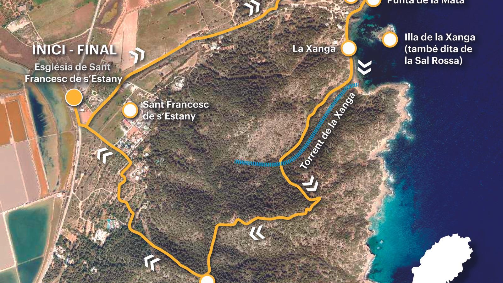
PalmOur route takes place on the eastern side of the immense municipality of San José de Sa Talaia, which covers the entire southern part of the island of Ibiza, where the Natural Park of the Salinas de Ibiza y Formentera stands out. A powerful cultural landscape and a natural heritage of incalculable value. We propose to explore a small part of the Salinas de Ibiza, visit the Salt Charger (La Xanga), the 16th-century defense tower, and climb Mount Corb, where we find the facilities of a former military observatory from the Civil War and World War II. Our starting point is the 18th-century church of San Francisco del Estany, one of the many that were built throughout the island following the constitution of the Diocese of Ibiza in 1782. This one, in particular, was built by the will of King Charles III to meet the religious needs of the workers of the sane. For regular public transport users, line 11 (Ibiza-Sant Jordi-les Salines) stops in front of the church.
[00 min] Before starting the walk, we can visit the church of San Francisco de s'Estany and the monument to the salt worker, the work of the Ibizan sculptor Pedro Juan Hormigo (San Antonio de Portmany, 1971), inaugurated in 2007. From here we start walking towards Las Salinas beach. A few meters away, we turn left along the Sal Rossa path and the Cargador tower, clearly signposted with a metal indicator from the Consell d'Eivissa (Eivissa Council). From now on, our steps are oriented towards gregal along a wide and comfortable dirt road, which is often used by vehicles. Soon we come across a wooden barrier [15 min], very close to the tower and the small group of houses and boatyards built around the Xanga (it would be 'Xanca' with the correct spelling, since the place name refers to the wooden post on which the fish was salted).
We leave the main track to the left and, without straying far from it, we advance to a cave, easily identifiable by a dry-wall fence that has just formed the space. [20 min] This is the cave where María Teresa León and Rafael Alberti took refuge for three weeks during that long summer of 1936, just after the coup d'état of July 18. They had arrived in Ibiza recently, on June 28. In 2021, the Consell de Eivissa planted a plaque on this site to commemorate the events, narrated by Maria Teresa León in her memoirs, first published in Argentina in 1970: "The mountain, like in Shakespearean performances, was full of outlaws. At dusk, we sat down to watch the rocks, we sat down to watch the rocks return, the island of Formentera in the near distance... For twenty days we lived on the mountain." (Memory of Melancholy. María Teresa León. Editorial Renacimiento, 2021) Alberti and León left the island on August 11, 1936, shortly before its final fall at the hands of the Spanish troops. To get to know this building, a true architectural gem of the 16th century that has come down to us in a sufficiently acceptable state of typological conservation, it must be borne in mind that its configuration responds to the different uses it has had to satisfy throughout history. It ended up becoming a strategic point for the defense of the salt loader and the port of Vila, together with the towers of the Puertas and the Espalmador, which watched over and looked after the air between Ibiza and Formentera.

From the Torre de la Sal Rubia or del Cargador, located on Punta de la Mata, we head towards some boatyards on the right [30 min], sheltered by the islands of Sal Rubia and Xanga. This crescent-shaped cove formerly housed all the facilities related to fishing and salt, the only activity that was carried out in the past on this site. Already in Roman times, the island was considered an important production point for purple (extracted from the shell of molluscs), which was used to dye fabrics, mainly wool.
From the boatyards we come out onto a cobbled street [35 min], near two large cisterns. We soon leave this road to follow a path along the seafront, on our left, towards other boatyards, located at the other end of the Xanga. Shortly before arriving [40 min], we change direction towards the interior (llebeo), towards a hill. We follow a small path marked with blue paint. [1 h 00 min] We come to a fork and turn right. Up to this point, the climb, although short, is noticeable to the legs. We come to some old barracks, cross a flat area and face the last steep climb before reaching the summit of Mount Corb Marí (120 m), where we find some old military installations [1 h 15 min].
It seems that the installation of the La Caleta anti-aircraft battery, at the western end of the Salinas Natural Park, completed the coastal defense line initiated during the Civil War to defend the port and airport of Ibiza in the 1940s at the beginning of World War II. A series of anti-aircraft guns and machine gun nests covered the eastern coast of Ibiza from Punta Arabí (Santa Eulària des Riu) to Mount Corb Marí, in the Salinas area (Sant Josep de sa Talaia). The command post was established here, from which the eight coastal batteries were also controlled. In fact, from the summit, one has a wide view of the entire southern coastline of the island of Ibiza.
We begin the descent towards Llebeig, facing the Salinas. He's a roasted tyrant and a bit negative, which requires taking precautions to avoid falling to the ground. [1 h 35 min] The trail leads us over a paved street in the Sant Francesc de s'Estany residential area, which we follow to the right. Shortly after, we leave the road to the right towards the north wind along a path that will take us to a new road. And from there, we continue straight downhill until we reach the road again (EI-900). A few meters away, on the right, is the church of Sant Francesc, the alpha and omega of our route [1 h 45 min].
Difficulty 2 out of 5
Distance 5.37 km
Elevation difference 147 m
Duration 1 h 45 min
Maximum altitude 160 m
Circular route
@Fita_a_Fita
