Difficulty 2 out of 5
Distance 8.05 km
Elevation difference 435 m
Duration 3 h 05 min
Maximum altitude 273 m
Circular route
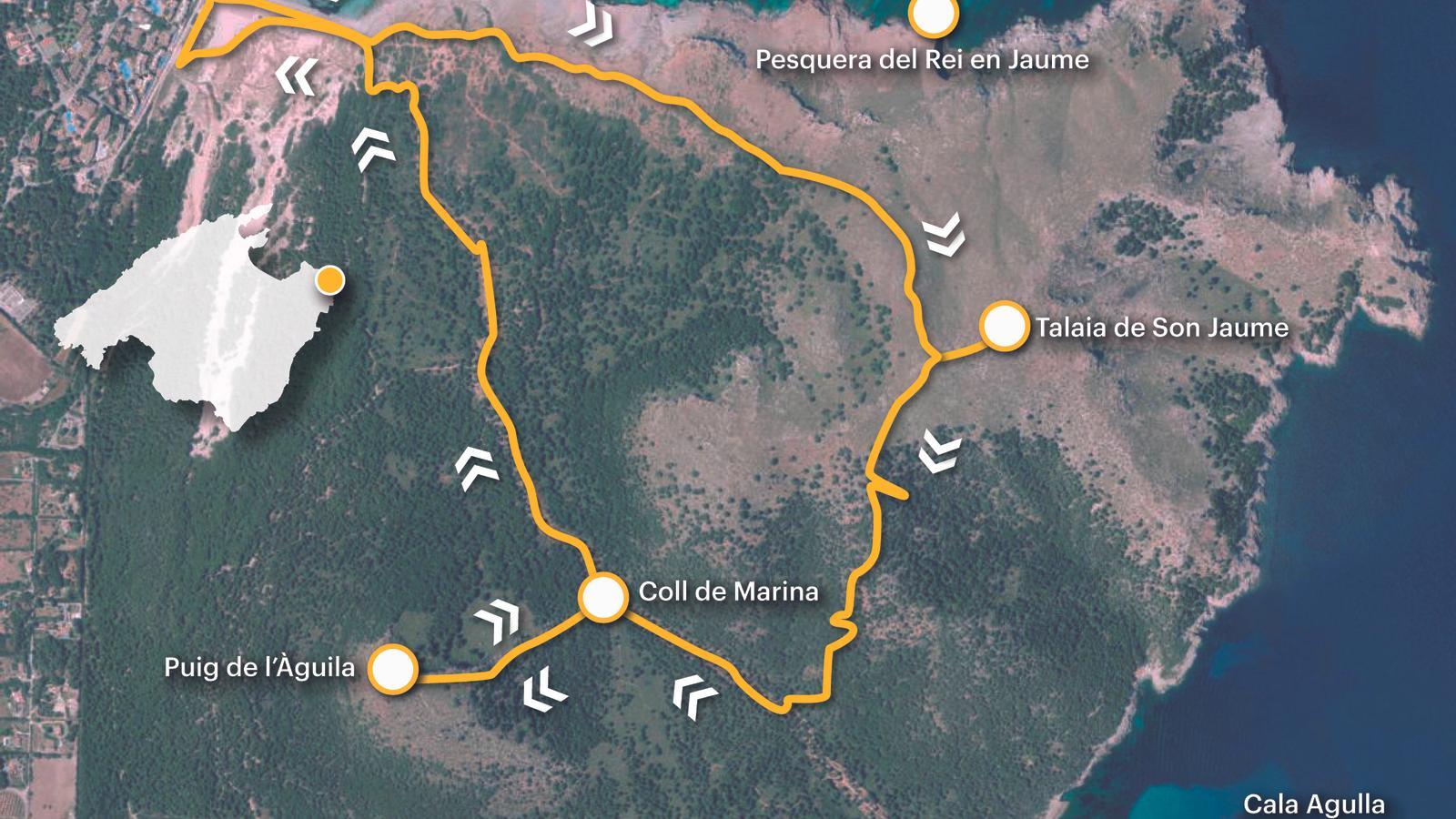
PalmIt's rare to find such a short itinerary that combines such a combination of elements to create a powerful cultural landscape and natural heritage. The route crosses the Cala Mesquida dune system, areas of accumulated sandy sediment that develop inland on most of the beaches of the Balearic Islands; it climbs to the Son Jaumell watchtower (273 m), a former 16th-century watchtower reused in the 19th century as another link in the optical telegraph linking Palma and Mahón, and continues to a second peak, Monte del Águila (234 m), where we find an archaeological site. The route starts and ends in the coastal town of Cala Mesquida, in the municipality of Capdepera, which until 1858 was part of Artà.
The Son Jaumell watchtower (1581) was part of the old coastal surveillance system that was established from the 16th century onwards to combat the continuous attacks by Turkish and Berber pirates. Also known as Cala Moltó or Cala Agulla, the tower stands at a height of 273 metres above sea level, on the same vertical as the sharp Cape of Freu, so named because it is the narrowest part of the channel that separates Mallorca and Menorca, between Cala Agulla and Cala Mesquida (olim, sa Mesquida). Currently, its body is sectioned towards the interior and its good side faces the sea. In the 19th century, it was part of the optical telegraph network that linked the Almudaina in Palma with the naval command in Mahon.
[00 min] We begin the walk from the streets of the coastal town of Cala Mesquida. Whether we arrive by public transport (L-422 Cala Rajada-Cala Mesquida/check routes and schedules on the website tib.org) as a private beach, our first steps lead towards the beach. We walk down a path that separates the hotels from the sandstone area. Unfortunately, the wooden walkways that cross the Mezquida dune system have been blocked for several years and are impassable. Therefore, for [5 min] we must descend to the beachfront to connect with the path that leads up to the Son Jaumell watchtower.

Facing east, we walk along the beach from one end to the other until we reach a pincer, at the height of an old machine-gun nest from the Civil War [20 min]. Many paths join together at this point. We must follow the one that points directly to the top of the mountain, our first landmark. We soon come to the first wooden stakes, which the Capdepera Town Council has used to mark several routes that run through the municipality. [25 min] As we begin to climb slowly, we leave the point of the Embarcadero to the left, probably an old loading dock, and the Sepulcro, a curious and enigmatic place name. The path runs between nun's pillows, reeds, and palmetto, and many stones. Other place names that define the coastal landscape of La Mezquida are the Río de sa Fusta, Penyalot and the fishing ground of Jaume I (in the NOTIB it is recorded as 'sa Pesquera de Don Jaume'), in memory of the passage in the royal chronicle that narrates the strategy to conquer Menorca.
The start of the climb is gentle, [45 min] but as we approach the base of the mountain, it becomes more difficult. A real thrill that, fortunately, is rewarded by the beautiful views of the surroundings. Above all, behind us, where the Albarca or Matzoc tower is already visible, on a discreet hill by the sea, is the more rugged Moreia watchtower, and to the left, Mount Tudossa, easily identifiable by the telephone antennas. A perspective of some of the most notable points of the Llevant Peninsula Natural Park. [55 min] We leave a ford to the left that descends from the tower's capcim and attack a steep, stepped section that will take us to the crest of the mountain. Then, at the top, we already have the Son Jaumell watchtower on the left [1 h 05 min]. Archduke Ludwig Salvator tells us that "up there is a geodetic marker with the date 1865; it is 271.46 meters above sea level. The Son Jaumell watchtower is an old signal tower, slightly conical, with a wooden staircase and an optical telegraph held by four iron chains. This watchtower exchanges signals with nearby Calicant and with Menorca." A review taken from the The Balearic Islands. The Balearic Islands described by words and engravings (1869-1890) highlights the strategic importance of this mountain over time, for the defense of the municipality and for military communications at the time, although all that remains of this is a badly damaged tower, of which, if no one fixes it soon, not even its stones will remain. From up here, we enjoy an excellent panoramic view of Gulló and Capdepera Point, and a little further to the east, Cabo Rojo and Atalaya Nova.
We descend along the normal route, which heads south, along a steep slope that leads us along the ridge to the point where it decisively drops off toward the ridge separating us from Monte del Águila. We follow the wooden stakes and some red paint marks that will take us down to the Cala Agulla path in La Mesquida, very close to the Marina pass, which is on our right (mastral). Once we reach this point (1 hour 40 minutes), we must look to our left, behind a lime kiln, for a wooden stake that marks the start of the path that climbs to the top of Monte del Águila. A short, rough climb. Just when we sense we are near the summit, we suddenly come across a margin made of some sizable stones (2 hours 00 minutes). These are precisely the remains of the fortress that was built on top of this peak and that appears to date from the Talayotic period. Once past this point, the slope gradually flattens out, and right in front of us, we can see the cairn rising from some rocks, marking the highest point of Monte del Águila [2 h 15 min].
We descend to the Marina pass along the same path we climbed. At the bottom, we turn left and continue toward Mezquida. The path leads directly to the wooden walkways that cross the dune system, which are now closed. We must therefore turn right to cross the beach again toward the coastal town of Cala Mesquida, where we end the walk [3 h 05 min].
Difficulty 2 out of 5
Distance 8.05 km
Elevation difference 435 m
Duration 3 h 05 min
Maximum altitude 273 m
Circular route
@Fita_a_Fita
