Costs of Flassada and Nicó, the most historic hauling
Route through the Sóller valley via ancient paths and immense cultural landscape at the foot of the great mountains of the Serra
PalmaAt the foot of the highest mountains in Mallorca, the route we present today is a long walk that aims to travel along some of the oldest and most beautiful public paths in the valley of the orange trees. Spaces where the imprint of the most historic movement of the area, which crosses olive groves and cultivated lands, orchards and urban areas, can still be felt. An itinerary where the main interest, but not the only one, focuses on the old bridle paths and the existence of an extensive and well-preserved network of public paths, a complex that forms a historical, cultural and ethnological heritage of the first magnitude. We want to describe, through walking and observation, a cultural landscape that necessarily must be written in capital letters. The Sóller valley, nestled between Puig del Teix to the west, the Alfàbia and Son Torrella mountain ranges to the south, and Puig Major and Montcaire mountain to the east, is one of the many hearts that beat strongly in the Tramuntana mountain range - World Heritage.

Given the parking difficulty in Sóller – prohibited in the town center and charged around it – we recommend using public transport. The L-204 is the most direct (Port de Sóller - Palma), while the L-203 takes a detour along the north coast (Port de Sóller - Deià - Valldemossa - Palma). Before leaving, check schedules and route availability on the Consorci de Transports de Mallorca website tib.org.
The route
[00 min] We start walking from Plaça de la Constitució towards Carrer de la Lluna, an emblematic street in Sóller, both for its history and its commercial bustle. It is named after the famous Casa de la Lluna, built in the 15th century and located at number 50. We take a few steps along a road that all hikers know well, as it is the classic exit route towards the Biniaraix ravine, among other destinations in the valley. However, as historian Plàcid Pérez Pastor points out, La Lluna is one of the three streets (the others are Carrer de la Victòria de l’11 de Maig and Carrer de Palou) that in medieval times marked the perimeter of Vila d’Ençà, a popular name for this part of the town of Sóller, then located on the right bank of the Torrent Major, now buried. The other part, on the left bank of the torrent and the church, was called Vila d’Enllà.
Once immersed in Carrer de la Lluna, we soon turn left onto Carrer de la Victòria de l’11 de Maig [05 min]. A few meters further on, we leave the bridge that crosses the Torrent Major on our left, from which the old Fàbrica Nova, founded in 1921 and dedicated to textiles, can be seen. Upon crossing the Biniaraix ravine, this street changes its name to Avinguda d’Astúries. We follow it and find ourselves in front of the municipal sports ground Camp d’en Maiol, at the height of the Fornalutx ravine [10 min]. We leave the football field on our right and continue our march along the Camí de la Figuera until the next fork, where we turn right onto Camí de les Argiles. Soon, on the right, we will see the signs that divert us towards Camí de la Costa d’en Flassada [15 min]. Regarding the toponym, the archivist of the Sóller Town Hall, Antoni Quetglas Cifre, points out that 'Flassada' is a nickname documented at least since the end of the 17th century and linked to the Bernat lineage (1695: Bernat); although the oldest reference to the naming of this path is found in Cardinal Despuig's map from 1784.

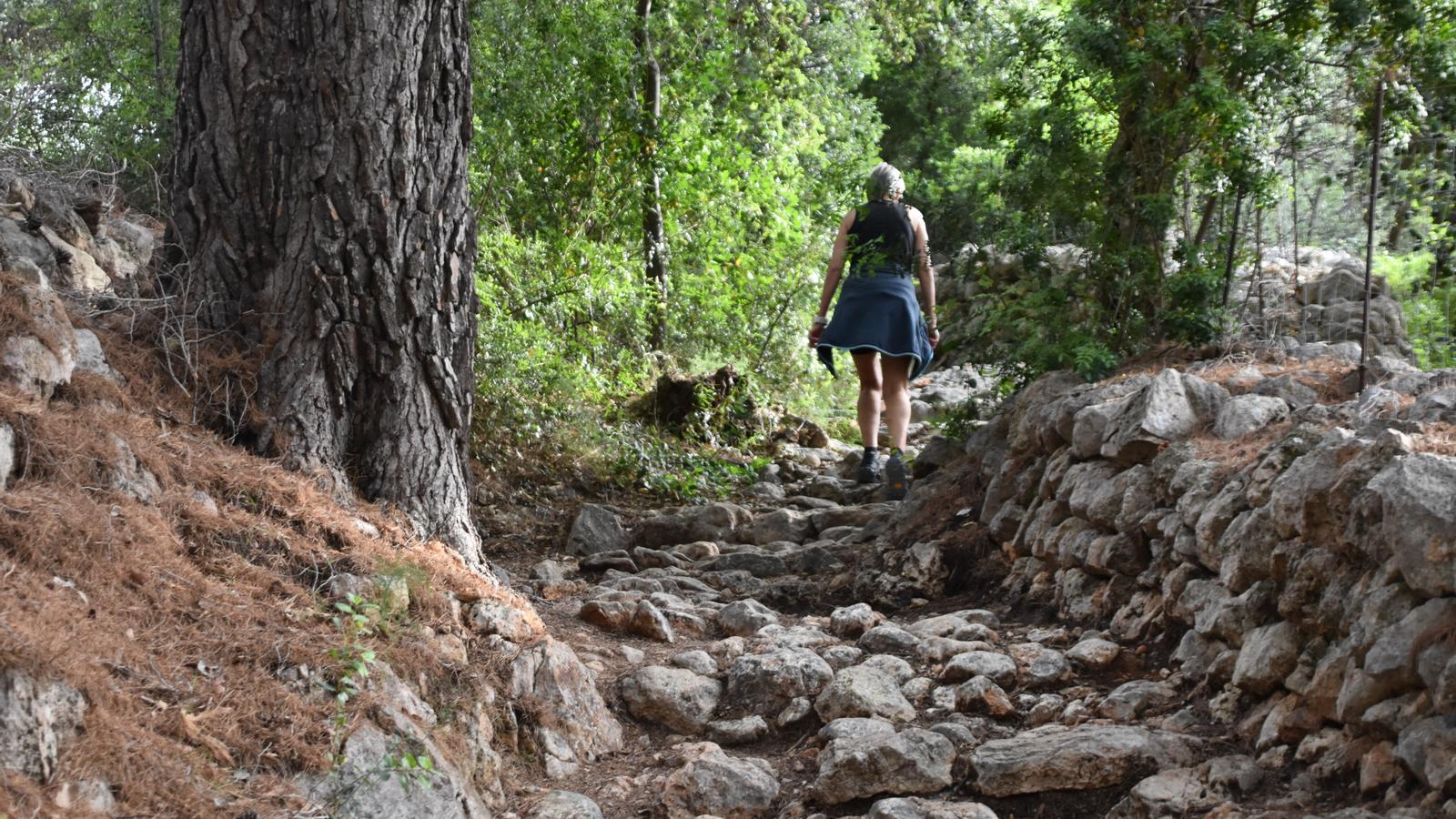
The first few meters climb sharply, leaving some houses aside. Soon the path narrows and becomes a passage of just over a meter [20 min], partially paved and with steps, bordered on both sides by stone walls. The path continues to climb through small properties, where the olive grove dominates. We find indicators of the Marjades path [30 min], to the right, which connects the Rave bridge with our route. We continue climbing until we reach the Puig Major road (Ma-10), built in 1961. We cross it with caution and follow the signs at the front. After a short stretch of concrete, our route continues along the newly paved path we find to the right of a house gate [40 min]. From this area, we will be able to enjoy the first views of the valley.
At the height of the Can Moscatell fountain [45 min], we join the Bàlitx path via the Capelleta. Here the Flassada coast ends, but not the route. We continue our ascent towards the Mirador de les Barques. Soon we emerge onto the Figuera path and an important crossroads, where one of the multiple variants of the Ruta de la Pedra en Sec passes, the one signposted as GR 221.6 [1 h 00 min]. To the left, we would head towards Port de Sóller, and to the right towards Fornalutx and Binibassí. We will opt for the indicators that point the way to Tuent via the Mirador de les Barques. In this section we combine the old Bàlitx road with the old and beautiful paved path.
Nickname linked to the Barceló lineage
We reach a new and more important crossroads [1 h 15 min]. We leave the Bàlitx path, a few metres from the Mirador de les Barques, and turn right onto the Costa d’en Nicó path, which starts out flat between dry stone walls before crossing the Ma-10. Regarding the toponym, archivist Antoni Quetglas again points out that ‘Nicó’ is a nickname documented in the mid-17th century and linked to the Barceló lineage of Fornalutx (1663: Pere Barceló). We begin the descent to Fornalutx along this old royal road. After crossing the Puig Major road twice more, the signs redirect us along the Bàlitx path via Fornalutx, with numerous shortcuts, sections of the old cobbled path. [1 h 55 min] We enter Fornalutx via Plaça street and then continue along Font street towards the Creuer path.
Located on the bridge of the Racó torrent [2 h 10 min], we leave the Alqueria fountain path to our left, and turn right onto the Creuer path. On this section of the route, we recover another old cobbled path that offers us a beautiful panorama of the surroundings and connects us with the Marroig path [2 h 30 min]. We will follow this old path that joins the valley with Monnàber, to the right, in the direction of Biniaraix. We enter it via Sant Josep street, between Rentadors and Cas Don [2 h 55 min]. From here, we walk towards Sóller via the Alqueria del Comte. Finally, via Lluna street, we will exit again onto Plaça de la Constitució, where our walk ends [3 h 30 min].
@Fita_a_Fita
