If you're interested in participating in this guided tour led by Juan Carlos Palos, please visit the following link . Additionally, if you're from Mallorca and interested in attending, the ARA Baleares is organizing a trip to Ibiza , which includes this tour, the Botafoc tour, and a trip to the port of La Savina in Formentera, on March 7, 8, and 9.
Milestone by milestone
Mount Vila, where the heart of Ibiza beats
A walk to discover and experience the history and heritage of an ancient city located on a hill overlooking the port and the sea.
Milestone by milestone
15/07/2025
5 min
PalmDalt Vila is the popular name given to the upper part of the historic center of Ibiza Town, surrounded by walls built during the second half of the 16th century. These walls are a splendid example of Renaissance fortifications with bastions, seven in total (San Pedro, Santiago, San Jorge, San Bernardo, Santa Tecla, Santa Lucía, and San Juan). Declared a National Historic-Artistic Monument in 1942, along with the cathedral tower and apse, the walls and Dalt Vila have also been a World Heritage Site since 1999. This walled urban area covers approximately 70,000 square meters. The renovation and fortification of the city of Ibiza in the 16th century was part of the plan to modernize the Mediterranean coastal defenses, promoted by Charles I and Philip II, to maintain and defend the Crown's territories during a time of continuous armed conflicts with France and the Ottoman Empire. The project was designed by the engineer Giovanni Battista Calvi (Milan, 1525-Perpignan, 1564), who initiator in 1555 of the works that would be continued twenty years later by Giovan Giacomo Palearo, called Fratin and, later, Antonio Saura, in the last decade of the 16th century.
Do you want to sign up?
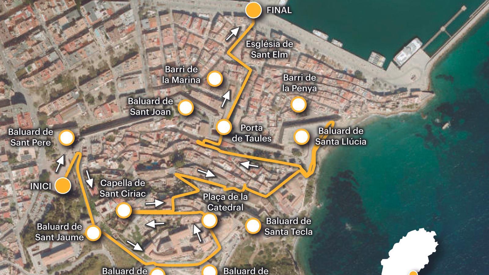
The following route traverses the heart of the historic center of Ibiza's capital and takes us to the port. This is an initiative of the ARA Baleares newspaper and the Port Authority of the Balearic Islands to share and publicize the secret heritage of our ports. We don't provide schedules, only the length of the route, the gradient, and the maximum height. Ultimately, it's a walk—which we can take alone or with others—through streets and squares steeped in history, legends, and an immense architectural and cultural heritage that requires time and tranquility to explore unhurriedly and with all five senses. The starting point of this heritage itinerary is the gardens of Plaza de la Reina Sofía, at the foot of Portal Nou, the access to Dalt Vila from the inland side, opposite the sea.
The route
From the esplanade of Plaza de la Reina Sofía, we head toward the steps of the Portal Nou. We begin to breathe in the antiquity of an ancient city that took shape atop the hill overlooking the entire bay of Ibiza. Upon entering, we find ourselves on the Sant Pere bastion, which extends westward, to our left. We turn right and head along the stepped coast toward the Sant Jaume bastion. This is the point where work on the Renaissance wall began in January 1555. As we ascend toward Plaza de la Catedral, we can see part of the medieval wall (10th century), the result of excavations in 1991, of the ancient Madina Yabisa, which remained operational for six hundred years.

As we ascend to Dalt Vila via the Ronda Calvi, we see Mount Molins to our right. The northern slope was used as a necropolis from the 6th century BC until the end of the Roman period. The most abundant element is the Punic hypogea. It is estimated that there were around 3,000 burial units on the entire mountain, only 350 of which are visible. To our left, the oldest urban area is already taking shape, with the Almudaina/castle and the Tower of Homage. The acropolis of the Punic and Roman city was initially located on the summit of Mount Vila. Later, around the 6th century AD, it was fortified and a protected area was created, which the Andalusians converted into a center of political and military power, beginning in the 10th century.
A certain medieval air can still be felt today in an environment expanded and embellished during the Renaissance. We have passed the bastions of Sant Jordi and Sant Bernat, and are approaching the bastion of Santa Tecla and the Revellí (a fortification separated from the main one to defend the bastions) at its feet. This bastion, located to the east of the cathedral, is the highest point in the city and a privileged vantage point towards the sea.
The heart of the town is here, in the old Plaza de las Tres Corts, also called Plaza de la Torreta in the 19th century and now known as Plaza de la Catedral, open between the castle, the cathedral, the pavilion, the university (Archaeological Museum of Ibiza and Formentera), the Chapel of El Salvador, and the Casa de La Salvador (viewpoint). This was the main meeting point for citizens and a place for major public celebrations from the Middle Ages until the 19th century. The cathedral of Santa María la Mayor, that is, the Virgin of the Snows, patron saint of Ibiza, was initially built as a church in the 13th century, after the Catalan conquest of 1235, on the old mosque of the madina. It underwent various renovations and expansions until the 18th century. With the establishment of the Diocese of Ibiza in 1782, until then a suffragan of Tarragona, the church attained the status of cathedral.
About two hundred meters from the Cathedral square is the Chapel of Sant Ciriac. We arrive there after a short walk along Calle Mayor. An inscription on a stone embedded in the wall informs us that "according to tradition, through this place the Christian troops entered the city on August 8, 1235, the feast day of San Ciriaco." We retrace our steps to leave Monte de Vila via Calle de la Portella. It's worth stopping for a moment in front of a beautiful 18th-century mansion at number 7 Calle Major. The writers Rafael Alberti and his wife, María Teresa León, often stayed here during their trip to Ibiza in the summer of 1936. It belonged to their friend Just Tur Puget.The Villa of palatial homes, where my friend Justo Tur lived, in a mullioned house"(Memory of melancholy. María Teresa León).
'The Year of Thunder'
Via Calle de la Portella, the old entrance to the medieval wall, we leave Vila Hill and descend toward the Puerta del Mar (Sea Gate) or Puerta de las Mesas (Mesa Gate). We continue along the narrow streets of Mariano Tur de Montis, Ponent, and Pere Turs to Plaça Espanya, near the Town Hall. Here we turn left onto Calle General Balanzat, in front of the Church of Sant Domingo, from where we access the Santa Llúcia Bastion. At this point, we recall "The Year of Thunder." It was on September 21, 1730, when lightning struck the powder magazine of the Santa Llúcia Bastion, exploding the 370 quintals of gunpowder inside. 15 people died, and the sound was so loud it was felt across the island.
We leave the bastion the way we entered and descend along Calle de la Carrossa to Plaça de la Vila. Along the way, we'll have skirted some gardens where the sculpture of the Ibizan priest and historian Isidor Macabich i Llobet (1883-1973) rests. We cross the Plaza de Armes and through the Portal de les Taules (1585) we emerge into the Marina neighborhood. To the right, we have the Penya neighborhood. Both, established outside the city walls, historically connect and relate Dalt Vila with its port and the sea.
We continue standing and exit in front of the church of Sant Telm, with a notable seafaring tradition. Our route ends on the port's front line, in front of the Monument to the Corsairs. The work of the Catalan architect August Font i Carreras, it was inaugurated in 1915, although the project was conceived in 1906 to commemorate the first centenary of the corsair Antoni Riquer's victory over the English brig Felicity.
The data
Difficulty 1 out of 5
Distance 2.11 km
Elevation difference 77 m
Duration ---
Maximum altitude 73 m
Non-circular route
@Fita_a_Fita
