Difficulty 3 out of 5
Distance 7.2 km
Elevation difference 84 m
Duration 2 h 35 min
Maximum altitude 57 m
Circular route
PalmThis week's route is included in the land and sea domain of the Albufera del Grao Natural Park. We are located north of Mahón, at the easternmost tip of the island, in a place of great cultural and scenic interest that was declared a Natural Park on May 4, 1995, and subsequently expanded in 2003. Its current area exceeds 5,000 hectares. This is undoubtedly the jewel in the crown of the Biosphere Reserve (1993), a result of social pressure against the most predatory urban development of the late 1970s. On the one hand, construction work on a housing estate began in 1973, and on the other, it was finally realized.
On this route, we explore the Punta de Gregal (northeast) of Puerto del Grau, originally an old fishing village, across rocky terrain perched high above the sea, along a route of paths and dirt tracks that we must navigate with great care. We'll pass the Cudia islets and reach Punta de la Galera, following tyrannos that traverse a shore of magnificent cliffs. Another visible feature of the surrounding geography is Columbus Island, where the remains of an early Christian basilica are preserved, as well as the memories of an old lazaretto located in the 18th century on this same site.

The not-too-long itinerary is a gift to the senses that must be savored in tranquility, respect, and a lot of common sense. As we often remember the boomers For younger generations, there's no 'screen' that surpasses the experience of contemplating this end of Menorca's coast. Because like the rest of the island, El Grau is a unique spot. Surrounded by low hills, juniper forests, and rush groves, this protected natural area includes a great diversity of environments with varying degrees of human intervention: wetlands, agricultural and livestock land, forests, a coastline with cliffs and beaches, islets, and a marine area. If you want to use public transport to get there, line 23 connects Maó and El Grau. As always, we recommend consulting the TIB Menorca website beforehand (menorca.tib.org).
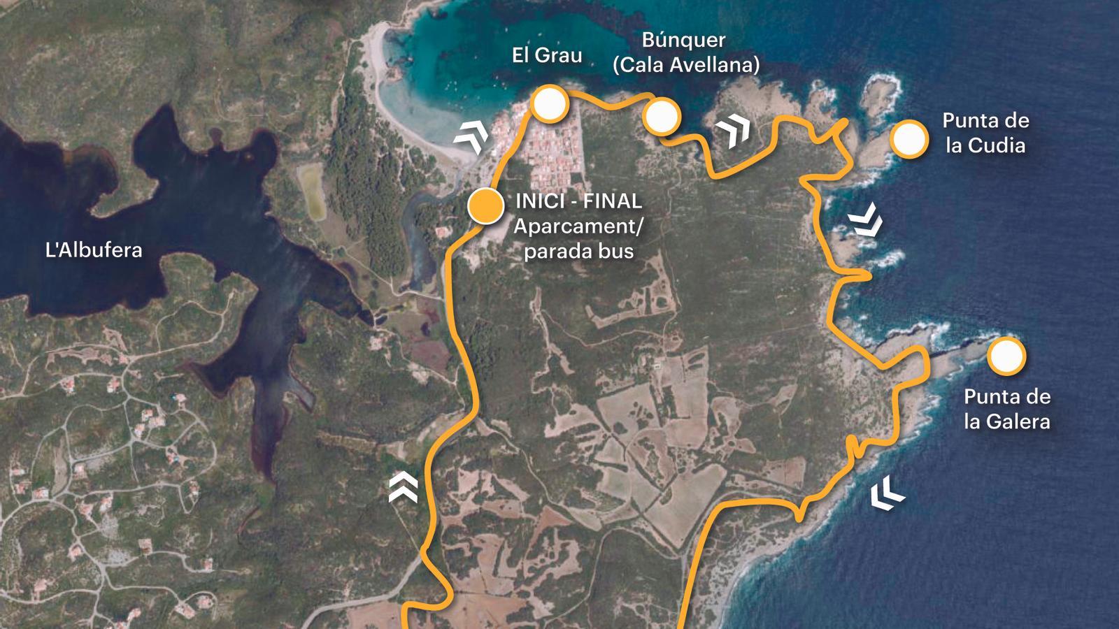
[00 min] We set off from the bus stop towards the coastal town of Grau. It is a humble, quiet, and friendly fishing village of neatly lined whitewashed houses, converted at the beginning of the 20th century into a summer residential area for a large number of Mahón families. Before immersing ourselves in its wildest natural landscape, with its magnificent cliffs, rocky inlets, and deep seas, we wander through the narrow streets of this small Mahón village, which began construction at the end of the 19th century. Arrival Street welcomes us, followed by Fishermen's Street, which leads us behind the front-line houses. After passing the short bank of Derecho Street, we have reached the end of the gregal del Grau [05 min].
From this point, a narrow strip of land invites us to take our first step off the asphalt. Thus, we begin our journey through the purest coastal space, where the intense green of the riverside vegetation blends with the grayer tones of a darkened rock. Between Punta del Cocó and Cala Avellana (also called Vellana), we find a machine gun nest and, at the top of a hill, a military observatory from the Civil War [15 min]. The visible imprint of history on the territory. The tyrannical cliff then descends rapidly to Cala Avellana, narrow, small, and almost imperceptible, where we find a small boathouse. As soon as we leave the cove, our path joins a dirt track that we follow to its end [35 min], a natural overlook over the islets of Cudia and Caló de la Cabra, which also offers us an excellent view of Colón Island.
We leave the tip of Cudia on the left and descend to the Jonc Bobal de Tramuntana via a narrow pass that is often confused with others opened by goats [45 min]. It is a well-sheltered, peaceful, and wild bay, with a very unique phyto-name. The trail continues inland, inside a narrow comma, and quickly takes flight along the scorched and harrowing slope on the left. Once we reach the top [55 min], we pass a dry wall and begin a new descent to the Jonc Boval de Migjorn. From this point on the route, we already have a complete view of the tip of Galera, the objective of our route. Meanwhile, if we turn our gaze towards the north, we can enjoy the wild shore we have just crossed, from the Grau to here. But, you live! The tresca continues.
We cross an area of slabs and climb a slope that places us on a natural esplanade opposite Punta de la Galera [1 h 10 min]. The point is formed by two monumental bodies of rock, about thirty meters high, linked by a narrow and discreet ridge that extends below, a few meters out to sea, in front of the outer rock. Inland, the emblematic site of Cudia Nova, a space where a major winemaking project has been underway for more than two decades. Begun in 1999 by Dr. Andrés Martínez-Jover and his five siblings, the objective was to transform a family estate with a cattle-raising tradition into a sustainable vineyard, producing good wines and a bright future. Currently, the vineyards occupy seven hectares on the north coast of Menorca, a Biosphere Reserve, within the Albufera del Grao Natural Park.
From Punta de la Galera we continue advancing over the rocky ridge in the direction now of Las Verjas [1 h 35 min], with beautiful views towards the sea and with the Toro mountain limiting our interior horizon. From here a dirt track is already visible on the Chaleco side, where we must direct our steps. [1 h 50 min] Once reached, we follow it to the right, inland. Shortly after, we come to a fork and to the right again until we join the Camí de Cavalls [2 h 10 min], between stakes 62 and 63 of stage 1 of the GR-223, which connects the Colársega of the port of Maó with the Grao lagoon. When you exit the road (Me-5), stand until you reach the fishing village [2 h 35 min].
Difficulty 3 out of 5
Distance 7.2 km
Elevation difference 84 m
Duration 2 h 35 min
Maximum altitude 57 m
Circular route
