Difficulty 4 out of 5Distance 10.1 kmElevation gain 477 mDuration 4 h 05 minMaximum altitude 598 mCircular route
Milestone by milestone
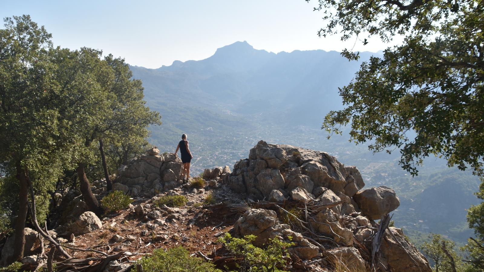
Penya Rocafort, from where all the charms of Sóller are seen
Trek through the inner slopes of the Teix massif through the Metro path and the Pi pass, steeped in history and tradition
22/05/2026
5 min
PalmaThe hill of Banya is a spur of 598 meters in height of the Teix massif. At the Tramuntana end, we find the Rocafort rock, our objective, a natural viewpoint from which we can contemplate all the charms of the Sóller valley. At its foot, there is a small viewpoint located at one of the stops of the Sóller train, which offers good views over the Sóller valley. All in all, an intense trek through the interior slopes of the Teix massif, via the Metro path and the Pi pass, which allows us to reflect on the description transmitted to us by the Catalan journalist and writer Josep Pla nearly sixty years ago. “The Sóller valley has all the charms that can be desired in this life: tranquility, silence, a mild climate, a warm and sweet air like a feather pillow.” (Les illes. Josep Pla i Casadevall. 1970, Edicions Destino).
The starting point of our route is at km 28 of the Ma-11, at the exit of the tunnel in the direction of Sóller. If we want to use public transport (L-204/tib.org), we must bear in mind that it does not stop at this point. Therefore, we will have to program an addition to the route from the capital of the Valley of the Oranges. One option is to do it via the Old Road to Ciutat.
The route
[00 min] We start walking from the same road, in the direction of the tunnel, along the right sidewalk, inside the safety barrier. It is a very short stretch that ends where the Teix stream appears. Our idea is to climb the right slope following a path made with railway sleepers, which is very affected by fallen trees from past storms.

Despite the difficulties, [05 min] we quickly find ourselves on the platform of the monument erected for the 75th anniversary of the inauguration of the Sóller train (1912-1987) and as a tribute to its main promoter, Jeroni Estades i Llabrés (Sóller, 1862 - Madrid, 1932), a Mallorcan financier and politician, deputy in the Spanish Parliament during the Bourbon Restoration.
We follow a stretch of track in the direction of Palma. [10 min] Before the bridge accessing the Major tunnel, to our right, greatly damaged by landslides, there is a path that connects the tracks with another path, much wider and firmer. It is a diversion of one of the two existing Metro paths in the area, which since the beginning of the 20th century connected the houses of Teix, in the Sóller pass (Bunyola), with the Sóller woods of the estate. The name of the path comes from the measurement used to cut pine logs (2.10 m), which was adapted to the size of the carts. The condition of the path has worsened over the years, mainly due to lack of use and maintenance. Now only hikers use it.
We bypass a deviation to the left [20 min] and continue uphill along the Metro path. After a steep turn, the path enters the Figuerota ravine, through which the Llemes stream flows, a tributary of the Teix stream. We must not lose sight of the landscape and the beautiful panoramas of the Alfàbia mountain range, the Sóller valley, and Puig Major. After a flat and straight stretch, [1 h 00 min] the path describes new uphill bends, at the height of the Ullastre pass (a marker on the right of the path indicates its location). We find a charcoal burner's hut and a lime kiln there. After the last bend [1 h 10 min], also to the right, we have the Pi pass, from where we will exit later.
The path turns gently south and its trace begins to be lost. In fact, it has no end, it just dissolves into the forest. We must open our eyes wide, because on the right we will find signs (markers and some small red arrow) of the track we must follow, crossing an old charcoal burner's hut, until we join the other Metro path that starts at the houses of Teix [1 h 30 min]. Once we are on this new mountain path (Metro path or Volada path), we join it on the right and follow it north until it begins to turn west. We will see a marker, on the right, apparently off the path, which leads us to a new dirt path that runs along the inner slope of the serreta del pujol d’en Banya, located on our right.
Despite the lush vegetation and some fallen trees, the path is easy to follow. The retaining wall is a good guide to follow it, always towards Tramuntana and to where it ends, above a charcoal burner's hut, very close to the cliffs that form the balcony of penya Rocafort [1 h 50 min]. We approach it with caution. It is a spur with very good views over the Sóller valley, from which all its charms can be contemplated. It is worth spending a while there, map in hand, to identify all the mountains and corners of the landscape that surround us.

Now we want to descend through the Pi pass. Initially, we have to retrace our steps to the point indicated previously. We return along the Pujol d’en Banya path, we follow the trail that crosses the charcoal burner's ranch and connects the two Metro paths. Once we are on the path we ascended, we stop at the point indicated as the start of the pass. [2 h 20 min] A few meters before the first downhill turn, we find on the left a cairn and a small red arrow pointing us east. After a short climb, we begin the descent along an old mule track, narrow and well-cliffed. Following the pass, the trail crosses a scree slope and we encounter sections heavily affected by fallen trees and stones. The cairns help us with orientation. Always level, towards the northeast.
La Sunyera
[2 h 55 min] The path leads us to a barrier-free gate – a hunting pass – where another well-defined path begins, which downhill should accompany us to another wider road. At the next fork to the left [3 h 05 min], we arrive at a porch, after which we find a closed barrier. The passage is to the right of the gate. The path, wider and clearer, takes us around the area known as la Sunyera. [3 h 15 min] We emerge onto the Camí Vell de Ciutat, which we follow to the right. Where the wooden signs lead us towards Sóller [3 h 35 min], we must continue straight ahead. A point is reached where the path narrows and forks [3 h 45 min]. To the left, we find a path that passes by an old hut and opens onto the train tracks, which we follow in the direction of Palma, to the right. A few meters further on, we find to the left the path that should take us to the road (Ma-11), a short distance from the Pont d'en Valls, the end of the route [3 h 55 min].
Data
@Fita_a_Fita
