Difficulty 3 out of 5Distance 9.57 kmElevation gain 80 mDuration 3 h 10 minMaximum altitude 60 mNon-circular route
Milestone by milestone
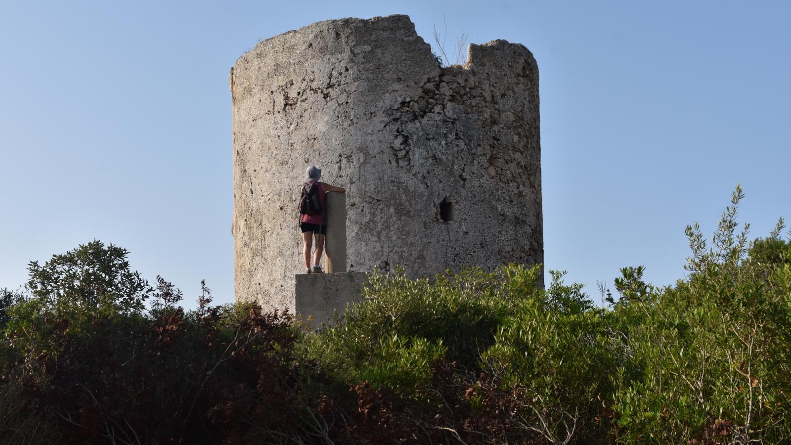
The Artrutx watchtower, the sentinel of southern Ciutadella
Trek along the southern Son Saura shore along the Camí de Cavalls, between coves and beaches of clear waters amidst a well-cut coast
19/06/2026
5 min
PalmaOur objective is the Artrutx watchtower (17th century) from the beaches of Son Saura. To begin with, a clarification, because we must not confuse the starting point of this route with the Son Saura sandbank, north of the municipality of Mercadal, to the right of the Fornells watchtower, also owned by the Comte de Torre-Saura Foundation – José María de Olives i Ponsich. In addition to the walk, we propose a dip in Cala en Turqueta before starting the return journey.
Therefore, we are on the southern bank of the municipality of Ciutadella, in the domains of the place called Son Saura Vell, a geographical area of the island of Menorca managed by the Comte de Torre-Saura Foundation. We will pass through the beaches of Son Saura (el Banyul and Bellavista) until we reach the Artrutx watchtower, built at the beginning of the 17th century for the control and surveillance of piracy. A few centuries later, in the 19th, this same construction served as a link in the military optical telegraph that communicated Mallorca and Menorca. We want to savor the heritage and historical value of the watchtower and the natural environment where it is located, all while we travel back and forth along the final stretch of stage 12 of the Camí de Cavalls.
We are about to set off, on foot and with a watchful eye, walking with all five senses. We only have to remember that we have public transport to access the beaches of Son Saura. The L-66 covers the Ciutadella-Poblat talaiòtic de Son Catlar-Son Saura line, although only during the summer months, from June 16 to September 14.
The route
[00 min] We start walking from the Son Saura car park. From here we head out to the sea, to Banyul beach, and quickly connect with the Camí de Cavalls (GR 223). Facing east, on our left, we advance following the wooden signs in the direction of Cala en Turqueta. [05 min] El Banyul is one of the two beaches that make up the Son Saura del sud sandy area, on the southern side of Ciutadella and in the shade of an extensive and lush pine forest. Very popular with families with children, the etymology of the toponym, probably of Latin origin, refers us to a place of baths or wetlands.

From Banyul beach we move to Bellavista beach [10 min], a little longer, with a dune system parallel to the beach and an interesting wetland area in the interior. To get there, we will cross the Abelles channel –which channels the water outflow towards the sea– by a small wooden bridge. From here we continue our walk along a wooden walkway. [15 min] Attention! Because halfway through we will exit to the left, via some stairs that lead us to a path that, through the scrubland, will allow us to head towards the Artrutx watchtower. We return to the sea at the height of an old Civil War bunker [20 min]. We cross the GR and continue our march along a path that advances over the rocky shore, by the sea, to Cala del Talaier [30 min], located between Punta del Pinar and Punta de na Bruna. Here we rejoin the Camí de Cavalls (stake 158/stage 12/GR 223).
We leave Cala del Talaier and, two stakes further on, at the height of 160 of stage 12, we abandon the main route, which heads to the right, and we follow a small path that runs parallel to a dry stone wall, which we have on our left. We ascend gently, with the wall always as our main reference. [50 min] Suddenly we have reached the highest point of this section, the watchtower is to our left; although to get there we have to follow the path a little further, now in a clear descent and always with the dry stone wall as a landmark to follow. Where the path turns to the right [1 h 00 min], almost invisible among the bushes, there is a small gate on the left that leads us to a wide and comfortable path, oriented towards the southwest, which we will follow until we reach another much wider and clearer track [1 h 10 min]. We turn left to face the last meters before reaching the main objective of the route [1 h 15 min].
The Artrutx watchtower, also called Cala en Turqueta, is located on top of a promontory just over 60 meters high above sea level. Its dating does not seem clear; for some researchers, it would be placed between the end of the 16th and the beginning of the 17th century. Its function was surveillance over a very jagged coast, with numerous coves and inlets where piracy often entered. During the 19th century, it was reused as a connection point for the Military Optical Telegraph of the Balearic Islands, which operated between 1852 and 1880 between Palma and Maó. Before leaving this place, let's review some verses by the always remembered Ciutadella native Joan Francesc López i Casasnoves (1952-2022): “Even if you ignore the path, / climb to the top of sa Talaia. / You will crown yourself with light / of October, this / seduction that the Mediterranean boasts / this midday”. (De sol a sol, 1999).
Cala en Turqueta
We leave the tower and retrace our steps until we regain the path we left before passing the small gate [1 h 30 min]. From here we continue descending along the path towards the sea. First we rejoin the GR and a short time later we reach Cala en Turqueta [1 h 55 min], where stage 12 of the Camí de Cavalls ends. Located between Punta dels Tambors and Na Foradada, we are in the ideal spot for a dip: a sea inlet of about 400 metres, surrounded by pine trees, fine sand caressing our feet and crystalline water to dive into. What more could we ask for? "Green desires prick hail in a luminous courtyard, / joy of light, maiden stars, envy so abundant. /… Unknown wisps the sea carries with the ribbon of wind and light, / allegories of fable and cotton foams". (The secrets of the Earth. Antoni Taltavull i Bosch, 1982).
For the return, the best option is to follow the signage of the Camí de Cavalls towards the beaches of Son Saura del sud. The route is almost flat and not very rugged. The dominant landscape consists, more clearly than on the way out, of wide areas of coastal rocky ground, alternated with small coves and sandy areas. Between Cala del Talaier and Bellavista beach, the path describes a wide curve between Punta del Pinar and Punta del Governador [2 h 50 min], from where we enjoy beautiful panoramas of the southern coast of Ciutadella. Upon reaching the first large sandy area of Son Saura, Bellavista, we must walk the entire wooden walkway that protects the dune system.
Little by little we approach the end of our walk. We take the last steps along Banyul beach before abandoning the Camí de Cavalls and turning to the right, towards the Son Saura car park, the point from which we started and where we now conclude our route [3 h 10 min].
The data
@Fita_a_Fita
