Difficulty 4 out of 5
Distance 24.17 km
Elevation difference 796 m
Duration 5 h 30 min
Maximum altitude 653 m
Non-circular route
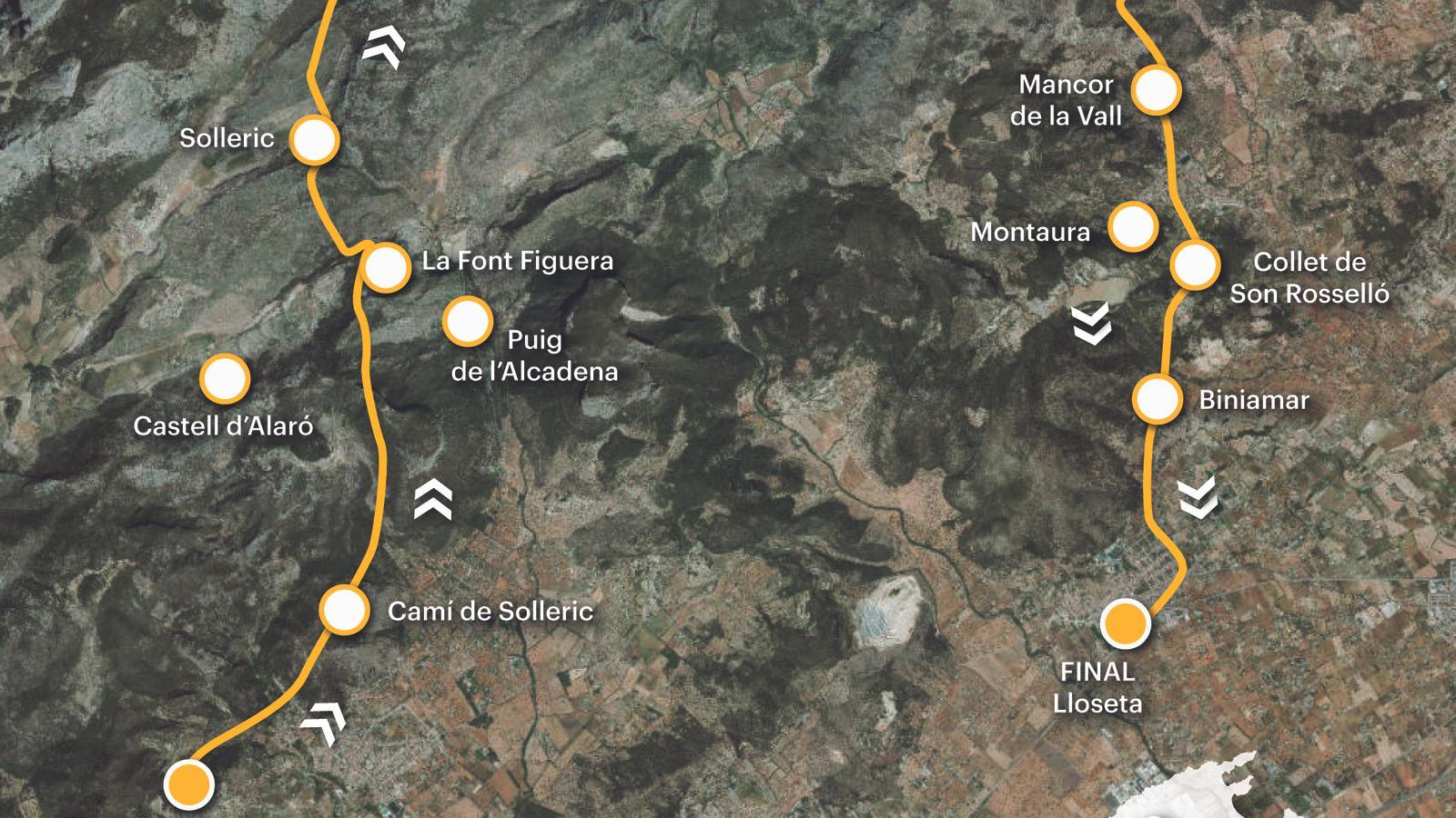
PalmIn the following itinerary, we propose a long and demanding trek along old paths in the Tramuntana mountains. These ancient routes, steeped in tradition, connect Alaró and Lloseta through historic estates, such as Solleric, Tossals, and Els Rafals, among others, and a cultural landscape steeped in history and legend. For both the outward and return journeys, we recommend taking the train. Check the routes, schedules, and availability of the different public service lines on the websites. tib.org and trensfm.com.
[00 min] From the bus stop at the start of Carrer Joan Alcover, we head into the village along Avenida de la Constitució. We pass the electricity pylon. On the right, the only remaining element of the original Alaró electricity factory, the first in Mallorca, inaugurated in 1901. Near Plaça de la Vila, the road changes its name and becomes Carrer Alexandre Rosselló. At the end, we turn right onto Carrer Can Ros and continue our walk, heading towards Gregal. Before leaving the village, we come across the Bànyols inn, which forms the corner of Carrer Can Manyoles, on the right, and Carrer Pontarró, where we continue our walk. A few meters further on, on the left, is Can Jaumico, a modernist mansion from the late 19th century. Finally, opposite the houses of Son Puça are the Pontarró wash houses, a popular-style public washhouse built around the 19th century. This was once where people would do their laundry, and it also has a drinking trough for the dead [10 min].

Following Calle de Solleric, we dive into the Alaroner foravila, then take steps along the Alaró to Bunyola road via Oriente (MA-2100). [25 min] After kilometer point 18, we leave the road to the right, along the Solleric path, guided by the signs for the Dry Stone Route (GR-221), which point us in the direction of the Tossals refuge. After ten minutes on asphalt, the path turns into dirt and winds between old sowing fields, guarded by the twin mountains, Alaró Castle and Alcadena. We cross the Solleric stream, which rises in the Comassema Valley and flows into the sea through the Albufera. We begin to gain altitude along a beautifully cobbled stretch of path. We then reach the houses of the Figuera fountain [1 h 00 min], built in the 18th century and initially called Sant Miquel de la Carena. These lands were part of the extensive Solleric estate. Our chimney runs along them, in front of the houses [1 h 15 min]. Miquel Vallès Reus de Berga i Canals (1723-1790), Marquis of Solleric and Viscount of Almadrà, undertook a major improvement plan for the estate in the mid-18th century. These included clearing and preparing for cultivation an area of one hundred quarters on the eastern slopes of the mountain. 10,000 olive tree grafts were planted.
We reach a small hill called Placeta d'en Sion [1 h 35 min], between the Font Fresca mountain (833 m) and the Corona mountain (575 m), where there is a small house renovated as a hunter's refuge, but which was formerly just a small shelter. This place, a meeting place for several important paths, has been known since the 1960s by a toponym that oral sources from Alarones relate to a master marger from Solleric who, according to the informants themselves, was a good place to store flagstones.
Guided by the wooden boundary stones of the GR, we begin the descent to the Almadrà stream along a path that crosses the sementer de la Sombra de las caminos (Shadow of the Roads) of Casa Nova. Documented since 1638, these houses – located to the left of the path – are a product of the expansion of olive cultivation in Solleric. Part of the Dry Stone Route, the path is a gem of ethnological heritage. It linked the Almallutx and Cúber valleys with the Pla and Raiguer valleys, and for centuries was the pilgrimage route to Lluc from Alaró and Bunyola. The arm's banks, with double walls to increase resistance on more unstable rock formations, are unique in the entire Tramuntana mountain range.
[1 h 55 min] We take the paved path that leads from Clot de Almadrà to the Tossals refuge, now in the municipality of Escorca. The signs lead us back along the old bridleway, which is much more beautiful and pleasant. We quickly find ourselves at the foot of the old houses of the Tossals Verds public estate [2 h 15 min], built in the 19th century, acquired by the Consell de Mallorca in 1986, and transformed into a refuge in 1995. The path continues to the left of the refuge. We follow the signs for Cases Velles and the Prat fountain, ignoring all those pointing toward La Coma. As we gain altitude, we gain a better view of the entire path we have traveled so far. [2 h 35 min] We pass through an unfenced gate and find a wooden signpost at the height of a kind of hill. We leave the path to the right and head east, where our route now continues. The flat path turns into a steep coastal path—the Rost—that points to the Almadrà hole. We continue towards the Carritxers barrier [2 h 45 min], where we access the Mancor path, once again in the Alaró area.
We walk along a section of the old route that connects Mancor with the lands of Almallutx via Tossals Verds. It is a mostly cobbled bridleway, registered as the Pinetons path in the Catalogue of the old paths of the Tramuntana mountain range (Council of Mallorca, 1993) Currently, badly damaged by forest fires and the lack of maintenance. We must be guided by the goals, always towards the east. It joins a dirt track that we will follow, oriented towards Chaloc, in the direction of Los Rafals [3 h 45 min]. From this point, a paved road begins that we will follow to Mancor de la Vall, where we will enter via Bartomeu Reus Street [4 h 05 min] crossing the town towards the Biniamar path, Terciopelo, also known as Villa Conchita, the house with fear of Mancor, and in front of it the health center. Biniamar, where we enter in front of the houses of Son Odre. Via Vent Street we leave the town through the Plaza de la Quintana [4 h 25 min].
Difficulty 4 out of 5
Distance 24.17 km
Elevation difference 796 m
Duration 5 h 30 min
Maximum altitude 653 m
Non-circular route
@Fita_a_Fita
