Difficulty 2 out of 5Distance 9.72 kmElevation gain 208 mDuration 2 h 30 minMaximum altitude 191 mCircular route
Milestone by milestone
The Stove, the most singular midday of the island of Formentera
Itinerary from the Mola plateau through its most fertile plains to a coastline sculpted by the continuous pounding of the sea
01/05/2026 - 19:37 h.
5 min
PalmaL’Estufador is a coastal area located on the southern slope of La Mola, between El Ram and Punta Roja. The strict toponym, documented as early as 1712, refers to a cove at the foot of the cliff where there is a fishermen's pier, close to the outlet of the Torrent de la Talaia and Punta de les Pesqueretes. There is also the path of L’Estufador, which connects these landing places with the nucleus of El Pilar de La Mola, crossing the territories of the Talaiassa estate. Popular tradition associates the name L’Estufador with peculiar cavities in the rock that, when receiving waves on stormy days, expelled water vertically, creating a spring. These rock formations were removed by fishermen during the first half of the seventies, to prevent them from favoring the accumulation of posidonia. (source: eeif.es)
Our starting and ending point is El Pilar de la Mola. A geographical area located at the easternmost tip of the island of Formentera which not only excels for its scrubland and southern cliffs, towards which we are heading, but also for the fertile plains of the northeast area, from where we begin our walk, and the simple and genuine architecture that evidences its antiquity as a human settlement. Documents indicate that after the Catalan conquest of the island, completed in early August 1235, the Archbishop of Tarragona, Guillem de Montgrí, established a community of Augustinian friars in La Mola who promoted the clearing of these fields.
However, Formentera has throughout its history been a small, isolated, and border territory. Its fragility has conditioned human settlement and activity, to the point of being depopulated on different occasions. It will not be until the 18th century that the definitive process of repopulation begins. It is at this time that the new population centers of Sant Francesc de Formentera, El Pilar de la Mola, and Sant Ferran de ses Roques and their respective churches are constituted.
The route
[00 min] We start the walk from the same esplanade of the Pilar de la Mola church, built in 1784, right next to where the island bus stops, which crosses the island from La Savina to La Mola. From here, facing east, we advance along the main road in the direction of the lighthouse. Soon, however, we turn right onto the Estufador path. We don't take long to find ourselves in the middle of extensive fields, over which the intense cereal activity is still felt today. The path passes between the Botigues windmill, on the right, and the Vell de la Mola windmill, on the left, from the 19th century. The first began to grind in 1893 and was abandoned in 1960.

After a first long and straight stretch, [10 min] we reach a first fork. We take the left path and, shortly after, arriving at the second, the right one. We continue straight south, along a wide dirt path. [20 min] We pass by the houses of Can Rita, which we leave on our right, and skirt several chalets, which remain on our left. A little further on, [30 min] at the height of a dry stone hut and a lime kiln, we begin the descent towards the sea, now along a paved path. Be alert, because a few minutes later [35 min], we leave the track on the left and follow an old cart track which, five minutes later, forks. [40 min] We follow the right one, which is actually the old “Estufador” path. The last section heads west, behind some chalets built on the front-line rocky outcrop, and connects with the paved track we left earlier.
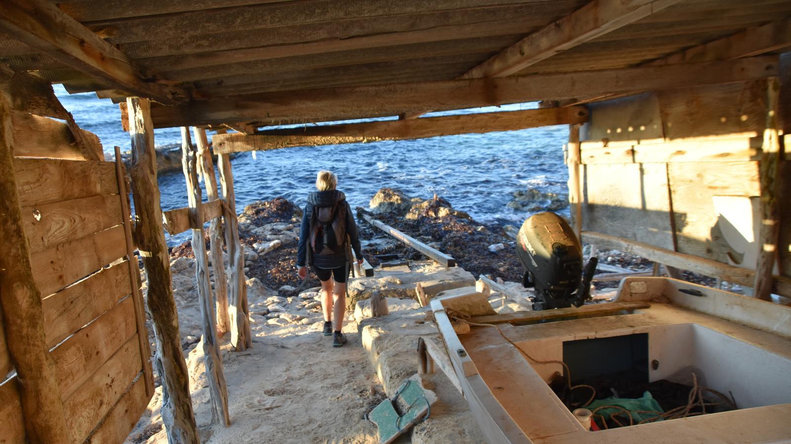
We are now at l’Estufador [50 min]. It is worth, before continuing towards Caló del Ram, going down to see the small boat sheds. They are accessed by a path that is a lesson in how to make use of geological formations. After a series of steps, it descends, brushing against the sinuous sand rocks. A rope serves as a handrail. Below us, a row of boat sheds with their boats and other fishing gear awaits us. The overall image becomes iconic, of high heritage value; it is an example of cultural landscape that speaks to us of the human relationship with the sea.
We leave the cove and rejoin the main route. From the end of the paved track [55 min], we take the first path that heads west, on our left, above the cliff. After crossing the ravine carved by the Talaia stream, the path gently descends until it places us well above Caló del Ram [1 h 25 min]. The landmarks are clear and the orientation is simple. Both the coastal nook and the jetty are located southwest of the Mola massif, between the Punta de la Fragata and the area known as el Copinar.
After visiting the cove and enjoying the perfumes of the southern port of Formentera, we begin the return to El Pilar de la Mola. Initially, we travel two hundred meters along the dirt track that descends from the main road through the Pujada forest. Soon, on the right, we find the start of the Ram path towards La Talaiassa (east/southeast), a narrow and very quiet track. [1 h 40 min] At the first fork, we turn left, uphill. And at the second, to the right, past the houses of La Talaiassa [2 h 05 min].

The highest point
La Talaiassa is the highest point on the island (200 m). The toponym immediately refers us to elevated places from which the sea was observed in ancient times with the aim of spotting possible hostile landings on the coast. Indeed, in 1760, when the military authorities chose suitable locations for the construction of defense towers, La Talaiassa was one of the chosen points, although none were built. On the other hand, the square tower that rises behind the houses was built in 1937 by the Francoist army, which had a very close anti-aircraft artillery battery stationed there. Finally, in the early years of the 19th century, also due to its privileged location, the roof of the Talaiassa house was used for the establishment of a triangulation vertex during the Franco-Spanish campaign to measure the meridian of Paris. Hosted by the Maians family, the French astronomer Francesc Aragó resided at La Talaiassa for four months during the winter of 1807 and calculated its latitude. The same vertex served in 1868 for the cartographic union of the Archipelago with the continent.
We leave the houses of La Talaiassa to our left and advance towards La Mola between cultivated lands. [2 h 15 min] At the next fork, we turn left and the asphalt appears, which we will not leave until the end of the route. Well on our way east, we approach El Pilar de la Mola, now via the Camí de la Pujada [2 h 20 min]. We will enter the village from behind the public school and finish in front of the Town Hall, at the height of the church [2 h 30 min].
The data
@Fita_a_Fita
