Difficulty 2 out of 5Distance 12.5 kmElevation gain 424 mDuration 3 h 50 minMaximum altitude 506 mCircular route
Milestone by milestone
The rock of Mola, perched on the history of Galilea
Route through old paths of this Puigpunyent hamlet to reach the top of an emblematic municipal property
Milestone by milestone
17/04/2026 - 19:54 h.
5 min
Palma“Galilea was known in the early 16th century as the mola of Cortei, a quite revealing toponym”. Tomàs Vibot and Just Hernàndez make this clear in the book Son Cortei, Conques i Galilea, published in 2009 by the Puigpunyent Town Hall: the establishment process of this nucleus is “a slow process motivated by inheritance policies” that led around 1586 to the segregation of an old farmstead of Bartomeu Cortei and the creation of small plots for the new settlers of the area.
The route we propose explores the mola of Galilea, this area of the Serra de Tramuntana that the Puigpunyent Town Hall acquired a year ago and which covers an area of almost 300,000 square meters, with significant cultural and architectural heritage within. To access the starting point of the walk, we can use line 201 (Galilea-Palma tib.org), which leaves us next to the Town Hall of Puigpunyent.
The route
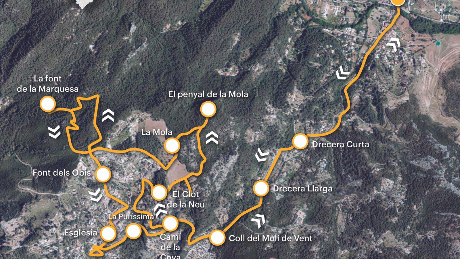
[00 min] Oriented to the southwest, we set off from the Vila bridge heading towards Galilea and Capdellà. We cross the oldest part of Puigpunyent, la Vila, established from the 18th century on the lands of Son Nét, with the church of l’Assumpció de Maria, in neo-Baroque style, as its main architectural landmark. We leave the village via the Ma-1032. Soon we cross the torrent de Conques, a tributary of the Riera. [20 min] After a short stretch on asphalt, we find the GR 221 markers that guide us towards the coll del Molí de Vent via the Drecera Curta, first, and the Drecera Llarga, afterwards. These are remains of the old Royal Road that existed before the construction of the current road in the early 1930s.
We emerge at the coll del Molí de Vent [35 min], at the height of the entrance to the Son Cortei estate. We advance a short stretch by road and at kilometer 8, we turn right, following the wooden signpost that indicates the path to the Cova dels Bous [40 min], part of the old Galilea path. After a very short and steep climb, we reach Carrer dels Bous, which we will follow until we reach the third turn on the right, Carrer de les Alzinetes, [55 min] along which we will continue our walk. When the street turns left, straight ahead we see a staircase, the costa d’en Mandons. At this point, we take the dirt path on our right, which leads directly to the camí de la Mola Gran, at the height of the Galilea snow house [1 h 00 min].

Clot de la Neu
In the book Les cases de neu de Mallorca (El Far publishing house, 2001), historical researcher Antoni Gorrias i Duran points out that no documentary references have been found to date its construction, only the fact that it is found excavated on the slopes of the "comellar de l’Infern", at 480 m above sea level and a few meters from the "pla dels Molins", near the "camí de la Mola". It is the only snow house located within an urban area, which limits its adjacent constructions. We do not find the typical porch of the snow houses, only the leveling terraces for snow collection, also used as olive groves. Before its rehabilitation, in 2019, a hut and a well were observed inside, still visible today, excavated and finished with a rectangular neck.
We recover the "camí de la Mola" and advance a few meters uphill until we reach the "pla dels Molins". We leave the main path on the right, towards the plain in front of us, where a path is clearly drawn, oriented east. As soon as we join it, we have the option to turn right to the "penyal del Corb" [1 h 10 min] and enjoy its splendid view. We return to the initial path and continue to a dry stone wall that we have right in front of us (northeast). The path crosses it and turns gently to the left (northeast). This is how we arrive at a very clear and visible fork: to the left, the path we will follow later towards the "cases de la Mola"; to the right, the route to the summit. We take this last path and a few meters later some cairns, visible on the left, indicate the climb to the "penyal de la Mola" (506 m) [1 h 30 min], with beautiful views of the Galatzó.
We go back to the last fork and continue straight to come out in front of the houses of La Mola [1 h 40 min]. The toponym originally refers to the entire mountain and later to the farmhouse that was established at the top of Galilea, from the division in the 17th century of the mola of en Cortei. From the houses, we follow the path marked by cypresses, which leads to the exit gate, near the threshing floor of La Mola. However, we will have to skirt the fence to the left until we reach the path where we entered before.
Font de la Marquesa
[1 h 50 min] We leave onto the path to La Mola, follow it to the right, past Soler's mill, until the next fork. We leave the steps of the Mandons slope to the left and turn right, following some wooden signs that point us towards the Molins path and the La Mola Petita path. The lane runs alongside Martí's mill and opens out onto a small hill, where the Font street arrives from the left, connecting Galilea with La Mola Petita. We continue straight ahead until we are in front of two chalets, Can Joan Petit and Can Fesol. [2 h 05 min] To the right, a sign points the way towards the Pi fountain and Puig de Galatzó. It immediately forks and heads rapidly downhill to the right until a road in the Son Nét development. [2 h 15 min] We reach a sort of small hill where, to the left, a dirt path begins which we follow straight ahead until we reach a new fork. We take the right, towards the Marquesa fountain [2 h 20 min]. Catalogued by the Puigpunyent Town Hall, it is a mine spring dug under an old track and dated between the 18th and 19th centuries.
We turn back to the previous crossroads and continue uphill until we reach a paved road which we take to the left. When we are in front of Can Fesol [2 h 35 min], we turn right down some stairs that lead to Font street and the Obis fountain, a spring that has been very problematic throughout history. We descend along Major street to the Immaculate Conception church [2 h 55 min]. On the way, we can go into number 8 of Clapers street and admire the painted tiles on its eaves or stop at the magical viewpoint of the Roca de l’Encantament.
From the church, we go down to the road via the Timbes path and turn left towards Puigpunyent, with great caution. We pass by the Puríssima cave, where we find an image of Our Lady of Lourdes. Some relate it to the fall of a rock onto the road in the 1930s which miraculously injured no one. We retrace our steps until we reach Puigpunyent [3 h 50 min].
The data
@Fita_a_Fita
