Difficulty 2 out of 5Distance 5.29 kmElevation gain 122 mDuration 1 h 45 minMaximum altitude 563 mCircular route
Milestone by milestone
The kite of the Dead and the Swallows, landscape sculpted drop by drop
Walk the paths around the Lluc sanctuary to get to know the karst modeling of the Serra up close, where the stone breathes in silence
Milestone by milestone
03/04/2026
4 min
PalmaOn this route we explore a part of the natural heritage that surrounds the sanctuary of Lluc. We are in the municipality of Escorca, one of the most extensive and at the same time least populated in Mallorca. It is home to the highest and also the most important and visited mountains on the island: Puig Major de Son Torrella (1436 m), Maçanella (1365 m), Puig Tomir (1104 m), Tossals Verds (1099 m), Puig de l’Ofra (1091 m) and Puig Roig (1003 m), among many others. The repopulation church of Sant Pere d’Escorca and the sanctuary of Lluc are the most important landmarks of the cultural landscape of the term. However, as a whole, from Andratx to Pollença, the Serra de Tramuntana must be understood as a mountain system of great geomorphological interest, declared a World Heritage Site by Unesco in the category of cultural landscape. It is a complex limestone relief, dominated by karst modeling, with strong contrasts between mountain and coast, and with an erosive dynamic marked by irregular water and Mediterranean processes.
Karst or karst relief is a form of terrestrial modeling caused by water through processes of erosion by chemical weathering. Striations, grooves, and cracks on the rock are a manifestation of this. This geological phenomenon is also characteristic of our Serra and takes its name from the Karst region in southern Slovenia, characterized by a landscape of sinkholes, imposing caves like Škocjan and Postojna, and underground rivers. A set very similar to that of Mallorca. Because karst relief is, therefore, characteristic of areas with the presence of limestone or other soluble carbonated rocks. It usually presents characteristic formations of surface corrosion, such as rills and sinkholes, or underground, such as abysses and caves, and the drainage system is fundamentally underground.
For this route, public transport is available: from Port de Sóller to Alcúdia, the L-231; and from Lluc to Muro, the L312. All information on timetables and route availability can be found on the website tib.org of the Consorci de Transports de Mallorca.

The route
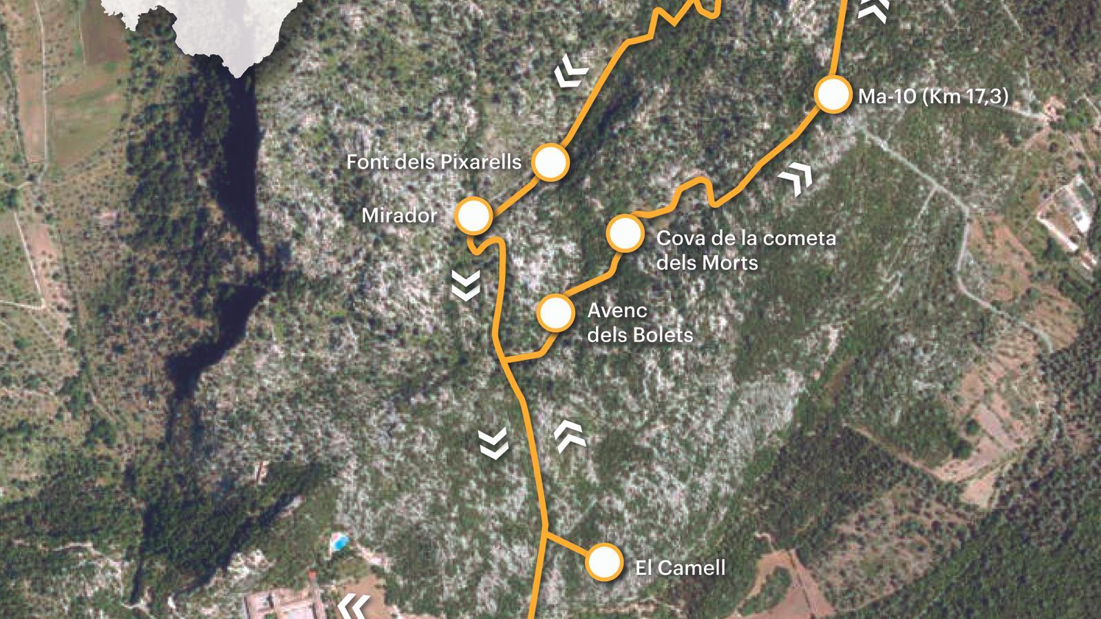
[00 min] Either from the bus stop or from the car park, for the start of our walk we must head towards the Plaça dels Pelegrins de Lluc. We leave the facade of the sanctuary to our left and orient our steps towards the road that connects with L'Acolliment and the botanical garden, through the area of the arcades. This is the starting point of the GR 221 variant that passes through Menut, following the old Pollença road, and joins the main route at the height of the houses of Binifaldó.
After crossing the old sports facilities of the Escolania de Lluc, we find the signs for the Pixarells route [10 min]. We leave the old Pollença road and cross the Lluc stream, to our left, by a small wooden bridge that takes us right into a karstic landscape, with its characteristic striations, grooves, and cracks, through which a old paved path, dressed in a lush holm oak forest, transits. A short and intense uphill stretch leaves us on a small plateau [15 min], with a silo roll to our left, a sign of the ancient and traditional use of the forest for charcoal production. To the right, facing southeast, the path that leads to El Camell. A short walk that the terrain transforms into a curious stone labyrinth. [20 min] El Camell is a natural formation that erosion caused by rainwater has shaped on the limestone rock that predominates over the soil and subsoil of the Lluc area; curiously, with the shape of a figure similar to that of a camel (or dromedary, because the figure has just one hump).
We return to the main path [25 min], to which we rejoin now on the right. Our walk continues along an old and wide paved path that soon forks [30 min]. We leave the Pixarells path, by which we will return, and turn right towards the 'cometa dels Morts'. The path descends slightly to level off upon reaching an open area [35 min], it is the 'dolina' – a depression in the shape of an oval or circular funnel typical of karst areas – of the 'cometa dels Morts', a toponym that refers to the cave located at the lowest part of the hollow. The name comes from the remains of burials from the Talaiotic period that were discovered there. The cave, signposted from the path, is on our left.
The cave of the 'cometa dels Morts'
In prehistoric times, the mountains of Escorca were already a place of settlement, burial and worship for the primitive inhabitants of the island. A total of 44 archaeological sites are proof of the strong imprint of the past on the territory. The Cave of the Comet of the Dead allows us to visualize on site the funeral rituals of the inhabitants of the Serra de Tramuntana in the Iron Age (1200-550 BC). If we visit the Lluc museum, we can contemplate a multitude of objects and pieces found in various excavations, mostly directed by Father Cristòfol Veny Melià (1926-2007), a missionary of the Sacred Heart of Lluc, an archaeologist and member of the CSIC, and director of the Spanish Institute of Prehistory between 1980 and 1985.
We return to the main path and follow it in the same direction we have maintained until now. A short, slightly uphill walk will lead us to the Pollença-Lluc road (Ma-10), at km 17.3 [50 min], between the entrance to the public estate of Menut and the Pixarells recreational area, towards which we direct our steps. We advance 300 meters in the direction of Pollença and will soon find the entrance to the aforementioned recreational area [55 min]. We enter it and follow the track that descends to the area of picnic tables, benches, and tables, until we reach the path that continues descending to the Pixarells area, another area that perfectly exemplifies the characteristic karst topography. Combined with the holm oak forest, it generates a magical and unsettling environment. We recommend exploring this environment calmly and with all five senses.
When the path begins to gain momentum to leave this hollow, "sa terra de ses olles des Puat de Menut", as Father Bartomeu Roig highlights in his book Les fonts del terme de Lluc i els seus itineraris (El Tall editorial, 1993), we find on the left the Pixarells fountain [1 h 10 min], so named because of the multitude of holes from which water gushes when it rains heavily. At the top of the path, we find the Pixarells viewpoint [1 h 20 min]. Shortly after, we close the circuit at the crossroads mentioned at the beginning of the walk. From here, we just have to retrace our steps to the sanctuary of Lluc [1 h 45 min].
The data
@Fita_a_Fita
